SECOND PREFATORY DISCUSSION
The parts of the earth where
civilization is found. Some
information about oceans, rivers, and zones.11
IN 12 THE BOOKS of philosophers who speculated about the condition of the world, it has been explained that the earth has a spherical shape and is enveloped by the element of water. It may be compared to a grape floating upon water.13
The water withdrew from certain parts of (the earth), because God wanted to create living beings upon it and settle it with the human species that rules as (God's) representative over all other beings.14 One might from this get the impression that the water is below the earth. This is not correct. The natural "below" of the earth is the core and middle of its sphere, the center to which everything is attracted by its gravity. All the sides of the earth beyond that and the water surrounding the earth are "above." When some part of the earth is said to be "below," it is said to be so with reference to some other region (of the earth).
The part of the earth from which the water has withdrawn is one-half the surface of the sphere of the earth. It has a circular form and is surrounded on all sides by the element of water which forms a sea called "the Surrounding Sea" (al-Bahr al-Muhit). It is also called lablayah,15 with thickening of the second l, or oceanos.16 Both are non-Arabic words. It is also called "the Green Sea" and "the Black Sea."
The part of the earth that is free from water (and thus suitable) for human civilization has more waste and empty areas than cultivated (habitable) areas. The empty area in the south is larger than that in the north. The cultivated part of the earth extends more toward the north. In the shape of a circular plane it extends in the south to the equator and in the north to a circular 17 line, behind which there are mountains separating (the cultivated part of the earth) from the elemental water. Enclosed between (these mountains) is the Dam of Gog and Magog. These mountains extend toward the east. In the east and the west, they also reach the elemental water, at two sections (points) of the circular (line) that surrounds (the cultivated part of the earth).
The part of the earth that is free from water is said to cover one-half or less of the sphere (of the earth). The cultivated part covers one-fourth of it. It is divided into seven zones.18
The equator divides the earth into two halves from west to east. It represents the length of the earth. It is the longest line on the sphere of (the earth), just as the ecliptic and the equinoctial line are the longest lines on the firmament. The ecliptic is divided into 360 degrees. The geographical degree is twenty-five parasangs, the parasang being 12,000 cubits or three miles, since one mile has 4,000 cubits. The cubit is twenty-four fingers, and the finger is six grains of barley placed closely together in one row.19 The distance of the equinoctial line, parallel to the equator of the earth and dividing the firmament into two parts, is ninety degrees from each of the two poles. However, the cultivated area north of the equator is (only) sixty-four degrees.20 The rest is empty and uncultivated because of the bitter cold and frost, exactly as the southern part is altogether empty because of the heat. We shall explain it all, if God wills.
Information about the cultivated part and its boundaries and about the cities, towns, mountains, rivers, waste areas, and sandy deserts it contains, has been given by men such as Ptolemy in the Geography 21 and, after him, by the author of the Book of Roger.22 These men divided the cultivated area into seven parts which they called the seven zones. The borders of the seven zones are imaginary. They extend from east to west. In width (latitudinal extension) they are identical, in length (longitudinal extension) different. The first zone is longer than the second. The same applies to the second zone, and so on. The seventh zone is the shortest. This is required by the circular shape that resulted from the withdrawal of the water from the sphere of the earth.
According to these scholars, each of the seven zones is divided from west to east into ten contiguous sections. Information about general conditions and civilization is given for each section.
(The geographers) mentioned that the Mediterranean which we all know branches off from the Surrounding Sea in the western part of the fourth zone. It begins at a narrow straits about twelve miles wide between Tangier and Tarifa, called the Street (of Gibraltar). It then extends eastward and opens out to a width of 600 miles. It terminates at the end of the fourth section of the fourth zone, a distance of 1,160 parasangs from its starting point. There, it is bordered by the coast of Syria. On the south, it is bordered by the coast of the Maghrib, beginning with Tangier at the Straits, then lfrigiyah, Barqah, and Alexandria. On the north, it is bordered by the coast of Constantinople, then Venice, Rome, France, and Spain, back to Tarifa at the Street (of Gibraltar) opposite Tangier. The Mediterranean is also called the Roman Sea or the Syrian Sea. It contains many populous islands. Some of them are large, such as Crete, Cyprus, Sicily, Majorca, and Sardinia.23
In the north, they say, two other seas branch off from the Mediterranean through two straits. One of them is opposite Constantinople. It starts at the Mediterranean in a narrow straits, only an arrow-shot in width. It flows for a three days' run and touches Constantinople. Then, it attains a width of four miles. It flows in this channel for sixty miles, where it is known as the Straits of Constantinople. Through a mouth six miles wide, it then flows into the Black Sea,24 and becomes a sea that, from there, turns eastward in its course. It passes the land of Heracleia (in Bithynia) 25 and ends at the country of the Khazars, 1,300 miles from its mouth. Along its two coasts live the Byzantine, the Turkish, the Bulgar (Burjin)'26 and the Russian nations.
The second sea that branches off from the two straits of the Mediterranean is the Adriatic Sea (Gulf of Venice). It emerges from Byzantine territory at its northern limit. Then, from Sant' Angelo (de' Lombardi), its western boundary extends from the country of the Venetians to the territory of Aquileia, 1,100 miles from where it started. On its two shores live the Venetians, the Byzantines (Rum), and other nations. It is called the Gulf of Venice (Adriatic Sea).
From the Surrounding Sea, they say, a large and wide sea flows on the east at thirteen degrees north of the equator. It flows a little toward the south, entering the first zone. Then it flows west within the first zone until it reaches the country of the Abyssinians and the Negroes (the Zanj)27 and Bib al-Mandeb in the fifth section of (the first zone), 4,500 parasangs from its starting point. This sea is called the Chinese, Indian, or Abyssinian Sea (Indian Ocean). It is bordered on the south by the country of the Negroes (Zanj) and the country of Berbera which Imru'ul-Qays mentioned in his poem.28 These "Berbers" do not belong to the Berbers who make up the tribes in the Maghrib. The sea is then bordered by the area of Mogadishu, Sufilah, and the land of al-Wigwiq,29 and by other nations beyond which there is nothing but waste and empty areas. On the north, where it starts, it is bordered by China, then by Eastern and Western India (al-Hind and as-Sind), and then by the coast of the Yemen, that is, al-Ahqif, Zabid, and other cities. Where it ends, it is bordered by the country of the Negroes, and, beyond them, the Beja.30
Two other seas, they say, branch off from the Indian Ocean. One of them branches off where the Indian Ocean ends, at Bib al-Mandeb. It starts out narrow, then flows widening toward the north and slightly to the west until it ends at the city of al-Qulzum in the fifth section of the second zone, 1,400 miles from its starting point. This is the Sea of al-Qulzum or Sea of Suez (Red Sea). From the Red Sea at Suez to Fustat 31 is the distance of a three days' journey. The Red Sea is bordered on the east by the coast of the Yemen, the Hijiz, and Jiddah,32 and then, where it ends, by Midyan (Madyan), Aila (Aylah), and Faran.33 On the west, it is bordered by the coast of Upper Egypt, 'Aydhib, Suakin, and Zayla' (Zila'), and then, where it begins, by the country of the Beja. It ends at al-Qulzum. It (would) reach the Mediterranean at al-'Arish. The distance between (the Red Sea and the Mediterranean) is a six days' journey. Many rulers, both Muslim and pre-Islamic, have wanted to cut through the intervening territory (with a canal) but this has not been achieved.
The second sea branching off from the Indian Ocean and called the Persian Gulf (the Green Gulf), branches off at the region between the west coast of India and al-Ahqaf in the Yemen. It flows toward the north and slightly to the west until it ends at al-Ubullah on the coast of al-Basrah in the sixth section of the second zone, 440 parasangs from its starting point. It is called the Persian Gulf (Persian Sea). It is bordered on the east by the coast of Western India, Mukrin, Kirmin, Firs, and al-Ubullah where it ends. On the west, it is bordered by the coast of al-Bahrayn, the Yamamah, Oman, ash-Shihr, and al-Ahgaf where it starts. Between the Persian Gulf and al-Qulzum lies the Arabian Peninsula, jutting out from the mainland into the sea. It is surrounded by the Indian Ocean to the south, by the Red Sea to the west, and by the Persian Gulf to the east. It adjoins the 'Iraq in the region between Syria and al-Basrah, where the distance between (Syria and the 'Iraq) is 1,500 miles. (In the 'Iraq) are al-Kufah, al-Qidistyah, Baghdad, the Reception Hall of Khosraw (at Ctesiphon)34 and al-Hirah. Beyond that live non-Arab nations such as the Turks, the Khazars, and others. The Arabian Peninsula comprises the Hijaz in the west, the Yamamah, al-Bahrayn, and Oman in the east, and in the south the Yemen along the coast of the Indian Ocean.
In the cultivated area (of the earth), they say, there is another sea to the north in the land of the Daylam. This sea has no connection with the other seas. It is called the Sea of Jurjan and Tabaristan (Caspian Sea). Its length is 1,000 miles, and its width 600. To the west of it lies Azerbaijan and the Daylam territory; to the east of it the land of the Turks and Khuwirizm; to the south of it Tabaristan; and to the north of it the land of the Khazars and the Alans.
These are all the famous seas mentioned by the geographers.
They further say that in the cultivated part of (the earth), there are many rivers. The largest among them are four in number, namely, the Nile, the Euphrates, the Tigris, and the River of Balkh which is called Oxus (Jayhun).
The Nile begins at a large mountain, sixteen degrees beyond the equator at the boundary of the fourth section of the first zone. This mountain is called the Mountain of the Qumr.35 No higher mountain is known on earth. Many springs issue from the mountain, some of them flowing into one lake there, and some of them into another lake. From these two lakes, several rivers branch off, and all of them flow into a lake at the equator which is at the distance of a ten days' journey from the mountain. From that lake, two rivers issue. One of them flows due north, passing through the country of the Nubah and then through Egypt. Having traversed Egypt, it divides into many branches lying close to each other. Each of these is called a "channel." All flow into the Mediterranean at Alexandria. This river is called the Egyptian Nile. It is bordered by Upper Egypt on the east, and by the oases on the west. The other river turns westward, flowing due west until it flows into the Surrounding Sea. This river is the Sudanese Nile.36 All the Negro nations live along its borders.
The Euphrates begins in Armenia in the sixth section of the fifth zone. It flows south through Byzantine territory (Anatolia) past Malatya to Manbij, and then passes Siflin, ar-Raggah, and al-Kufah until it reaches the Marsh (alBatha') between al-Basrah and Wasit. From there it flows into the Indian Ocean. Many rivers flow into it along its course. Other rivers branch off from it and flow into the Tigris.
The Tigris originates in a number of springs in the country of Khilat, which is also in Armenia. It passes on its course southward through Mosul, Azerbaijan, and Baghdad to Wasit. There, it divides into several channels, all of which flow into the Lake of al-Basrah and join the Persian Gulf. The Tigris flows east of the Euphrates. Many large rivers flow into it from all sides. The region between the Euphrates and the Tigris, where it is first formed, is the Jazirah of Mosul, facing Syria on both banks of the Euphrates, and facing Azerbaijan on both banks of the Tigris.
The Oxus originates at Balkh, in the eighth section of the third zone, in a great number of springs there. Large rivers flow into it, as it follows a course from south to north. It flows through Khurasan, then past Khurasan to Khuwarizm in the eighth section of the fifth zone. It flows into Lake Aral (the Lake of Gurganj) which is situated at the foot [north?] of the city of (Gurganj). In length as in width, it extends the distance of one month's journey. The river of Farghanah and Tashkent (ash-Shash),37 which comes from the territory of the Turks, flows into it. West of the Oxus lie Khurasan and Khuwarizm. East of it lie the cities of Bukhari, at-Tirmidh, and Samarkand. Beyond that are the country of the Turks, Farghanah, the Kharlukh,38 and (other) non-Arab nations.
(All) this was mentioned by Ptolemy in his work and by the Sharaf (al-Idrisi) in the Book of Roger. All the mountains, seas, and rivers to be found in the cultivated part of the earth are depicted on maps and exhaustively treated in geography. We do not have to go any further into it. It is too lengthy a subject, and our main concern is with the Maghrib, the home of the Berbers, and the Arab home countries in the East.
God gives success.
SUPPLEMENTARY NOTE
TO THE SECOND PREFATORY DISCUSSION
The northern quarter of the earth has more civilization
than the southern quarter. The reason thereof.
WE KNOW FROM OBSERVATION and from continuous tradition that the first and the second of the cultivated zones have less civilization than the other zones. The cultivated area in the first and second zones is interspersed with empty waste areas and sandy deserts and has the Indian Ocean to the east. The nations and populations of the first and second zones are not excessively numerous. The same applies to the cities and towns there.
The third, fourth, and subsequent zones are just the opposite. Waste areas there are few. Sandy deserts also are few or non-existent. The nations and populations are tremendous. Cities and towns are exceedingly numerous. Civilization has its seat between the third and the sixth zones. The south is all emptiness.
Many philosophers have mentioned that this is because of the excessive heat and slightness of the sun's deviation from the zenith in the south. Let us explain and prove this statement. The result will clarify the reason why civilization in the third and fourth zones is so highly developed and extends also to the fifth, <sixth,> and seventh zones.
We say: When the south and north poles (of heaven) are upon the horizon, they constitute a large circle that divides the firmament into two parts. It is the largest circle (in it) and runs from west to east. It is called the equinoctial line. In astronomy, it has been explained in the proper place that the highest sphere moves from east to west in a daily motion by means of which it also forces the spheres enclosed by it to move. This motion is perceptible to the senses. It has also been explained that the stars in their spheres have a motion that is contrary to this motion and is, therefore, a motion from west to east. The periods of this movement differ according to the different speeds of the motions of the stars.
Parallel to the courses of all these stars in their spheres, there runs a large circle which belongs to the highest sphere and divides it into two halves. This is the ecliptic (zodiac). It is divided into twelve "signs." As has been explained in the proper place, the equinoctial line intersects the ecliptic at two opposite points, namely, at the beginning of Aries and at the beginning of Libra. The equinoctial line divides the zodiac into two halves. One of them extends northward from the equinoctial line and includes the signs from the beginning of Aries to the end of Virgo. The other half extends southward from it and includes the signs from the beginning of Libra to the end of Pisces.
When the two poles fall upon the horizon <which takes place in one particular region> among all the regions of the earth, a line is formed upon the surface of the earth that faces the equinoctial line and runs from west to east. This line is called the equator. According to astronomical observation, this line is believed to coincide with the beginning of the first of the seven zones. All civilization is to the north of it.
The north pole gradually ascends on the horizon of the cultivated area (of the earth) until its elevation reaches sixtyfour degrees. Here, all civilization ends. This is the end of the seventh zone. When its elevation reaches ninety degrees on the horizon - that is the distance between the pole and the equinoctial- line-then it is at its zenith, and the equinoctial line is on the horizon. Six of the signs of the zodiac, the northern ones, remain above the horizon, and six, the southern ones, are below it.
Civilization is impossible in the area between the sixtyfourth and the ninetieth degrees, for no admixture of heat and cold occurs there because of the great time interval between them. Generation (of anything), therefore, does not take place.
The sun is at its zenith on the equator at the beginning of Aries and Libra. It then declines from its zenith down to the beginning of Cancer and Capricorn. Its greatest declination from the equinoctial line is twenty-four degrees.
Now, when the north pole ascends on the horizon, the equinoctial line declines from the zenith in proportion to the elevation of the north pole, and the south pole descends correspondingly, as regards the three (distances constituting geographical latitude).39 Scholars who calculate the (prayer) times call this the latitude of a place. When the equinoctial line declines from the zenith, the northern signs of the zodiac gradually rise above it, proportionately to its rise, until the beginning of Cancer is reached. Meanwhile, the southern signs of the zodiac correspondingly descend below the horizon until the beginning of Capricorn is reached, because of the inclination of the (two halves of the zodiac) upwards or downwards from the horizon of the equator, as we have stated. The northern horizon continues to rise, until its northern limit, which is the beginning of Cancer, is in the zenith. This is where the latitude is twenty-four degrees in the Hijaz and the territory adjacent. This is the declination from the equinoctial at the horizon of the equator at the beginning of Cancer. With the elevation of the north pole (Cancer) rises, until it attains the zenith. When the pole rises more than twenty-four degrees, the sun descends from the zenith and continues to do so until the elevation of the pole is sixty-four degrees, and the sun's descent from the zenith, as well as the depression of the south pole under the horizon, is the same distance. Then, generation (of anything) stops because of the excessive cold and frost and the long time without any heat.
At and nearing its zenith, the sun sends its rays down upon the earth at right angles. In other positions, it sends them down at obtuse or acute angles. When the rays form right angles, the light is strong and spreads out over a wide area, in contrast to what happens in the case of obtuse and acute angles. Therefore, at and nearing its zenith, the heat is greater than in other positions, because the light (of the sun) is the reason for heat and calefaction. The sun reaches its zenith at the equator twice a year in two points of Aries and Libra. No declination (of the sun) goes very far. The heat hardly begins to become more temperate, when the sun has reached the limit of its declination at the beginning of Cancer or Capricorn and begins to rise again toward the zenith. The perpendicular rays then fall heavily upon the horizon there (in these regions) and hold steady for a long time, if not permanently. The air gets burning hot, even excessively so. The same is true whenever the sun reaches the zenith in the area between the equator and latitude twentyfour degrees, as it does twice a year. The rays exercise almost as much force upon the horizon there (at this latitude) as they do at the equator. The excessive heat causes a parching dryness in the air that prevents (any) generation. As the heat becomes more excessive, water and all kinds of moisture dry up, and (the power of) generation is destroyed in minerals, plants, and animals, because (all) generation depends on moisture.
Now, when the beginning of Cancer declines from the zenith at the latitude of twenty-five degrees and beyond, the sun also declines from its zenith. The heat becomes temperate, or deviates only slightly from (being temperate). Then, generation can take place. This goes on until the cold becomes excessive, due to the lack of light and the obtuse angles of the rays of the sun. Then, (the power of) generation again decreases and is destroyed. However, the destruction caused by great heat is greater than that caused by great cold, because heat brings about desiccation faster than cold brings about freezing.
Therefore, there is little civilization in the first and second zones. There is a medium degree of civilization in the third, fourth, and fifth zones, because the heat there is temperate owing to the decreased amount of light. There is a great deal of civilization in the sixth and seventh zones because of the decreased amount of heat there. At first, cold does not have the same destructive effect upon (the power of) generation as heat; it causes desiccation only when it becomes excessive and thus has dryness added. This is the case beyond the seventh zone. (All) this, then, is the reason why civilization is stronger and more abundant in the northern quarter. And God knows better!
The 40 philosophers concluded from these facts that the region at the equator and beyond it (to the south) was empty. On the strength of observation and continuous tradition, it was argued against them that (to the contrary) it was cultivated. How would it be possible to prove this (contention)? It is obvious that the (philosophers) did not mean to deny entirely the existence of civilization there, but their argumentation led them to (the realization) that (the power of) generation must, to a large degree, be destroyed there because of the excessive heat. Consequently, civilization there would be either impossible, or only minimally possible. This is so. The region at the equator and beyond it (to the south), even if it has civilization as has been reported, has only a very little of it.
Averroes 41 assumed that the equator is in a symmetrical position 42 and that what is beyond the equator to the south corresponds to what is beyond it to the north; consequently, as much of the south would be cultivated as of the north. His assumption is not impossible, so far as (the argument of) the destruction of the power of generation is concerned. However, as to the region south of the equator, it is made impossible by the fact that the element of water covers the face of the earth in the south, where the corresponding area in the north admits of generation. On account of the greater amount of water (in the south), Averroes' assumption of the symmetrical (position of the equator) thus turns out to be impossible. Everything else follows, since civilization progresses gradually and begins its gradual progress where it can exist, not where it cannot exist.
The assumption that civilization cannot exist at the equator is contradicted by continuous tradition. And God knows better!
{
After this discussion, we wish to draw a map of the earth,43 as was done by the author of the Book of Roger. Then, we shall give a detailed description of the map.
DETAILED DESCRIPTION OF THE MAP44
THIS DESCRIPTlON is twofold. There is a detailed description and a general description.
The detailed description consists of a discussion of each country, mountain, sea, and river of the cultivated part of the earth. This discussion will be found in the following section.
The general description consists of a discussion of the division of the cultivated part of the earth into seven zones, their latitudinal (extension), and the length of their days. Such is the contents of this section.
Let us begin to explain these things. We have mentioned before that the earth floats upon the elemental water like a grape.45 God's plan for civilization and for the elemental generation of life resulted in making part of (the earth) free of water.
The part that is free of water is said to constitute one-half the surface of the earth. The cultivated part is one-fourth of it. The rest is uncultivated. According to another opinion, the cultivated part is only one-sixth of it. The empty areas of the part which is free of water lie to the south and to the north. The cultivated area in between forms a continuum that stretches from west to east. There is no empty area between the cultivated part and the (Surrounding) Sea in these two directions.
They further said: Across the cultivated part of the earth an imaginary line runs from west to east facing the equinoctial line (of the firmament) in regions where the two poles of the firmament are on the horizon. At this line civilization begins. It extends from there northwards.
Ptolemy said: "As a matter of fact, civilization extends beyond that line to the south." He indicated the latitudinal extension, as will be mentioned .46
Ishaq b. al-Hasan al-Khazini 47 expresses the opinion that beyond the seventh zone (to the north) there is another civilization. He indicated its latitudinal extension, as we shall
|
KEY TO THE MAP |
|||
|
1 |
South |
41 |
Mukrin |
|
2 |
West |
42 |
Kirmin |
|
3 |
North |
43 |
Firs |
|
4 |
East |
44 |
al-Bahlus |
|
5 |
Empty beyond the equator because of the heat |
45 |
Azerbaijan |
|
6 |
Equator |
46 |
Desert |
|
7 |
Lamlam Country |
47 |
Khurasin |
|
8 |
Maghzawah (Maguzawa?) |
48 |
Khuwirizm |
|
9 |
Kanem [Country |
49 |
Eastern India |
|
10 |
Bornu |
50 |
Tashkent |
|
11 |
Gawgaw |
51 |
Soghd |
|
12 |
Zaghiy |
52 |
China |
|
13 |
at-Tijuwin |
53 |
Tughuzghuz |
|
14 |
Nubia |
54 |
Gascogne |
|
15 |
Abyssinia |
55 |
Brittany |
|
16 |
Ghanah |
56 |
Calabria |
|
17 |
Lamtah |
57 |
France |
|
18 |
as-Sus |
58 |
Venice |
|
19 |
Morocco |
59 |
Germany (Alaminiyah) |
|
20 |
Tangier |
60 |
Macedonia |
|
21 |
Sinhijah |
61 |
Bohemia |
|
22 |
Dar'ah |
62 |
Jathuliyah |
|
23 |
Ifriqiyah |
63 |
Jarmaniyah |
|
24 |
Fezzan |
64 |
al-Baylagin |
|
25 |
Jarid |
65 |
Armenia |
|
26 |
Kawir |
66 |
Tabaristan |
|
27 |
Desert of Berenice |
67 |
Alans |
|
28 |
Inner Oases |
68 |
Bashqirs |
|
29 |
Upper Egypt |
69 |
Bulgars |
|
30 |
Egypt |
70 |
Pechenegs |
|
31 |
Beja |
71 |
Stinking Land |
|
32 |
Hijiz |
72 |
Waste Country |
|
33 |
Syria |
73 |
Magog |
|
34 |
Yemen |
74 |
Ghuzz |
|
35 |
Yamimah |
75 |
Tiirgish |
|
36 |
al-Basrah |
76 |
Adhkish |
|
37 |
'Iraq |
77 |
Khallukh |
|
38 |
ash-Shihr |
78 |
Gog |
|
39 |
Oman |
79 |
Kimik |
|
40 |
Western India |
80 |
Empty in the north because of the cold |
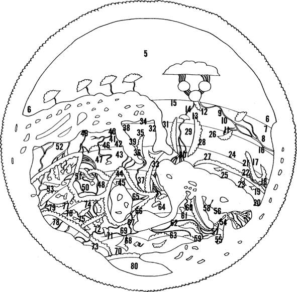
mention. 48 Al-Khazini is one of the leading scholars in this craft (geography).
* Further, the ancient philosophers divided the cultivated part of the earth in the north into seven zones by means of imaginary lines running from west to east. They maintain that these zones have different latitudinal extensions. This will be discussed in detail.
The first zone runs along the equator, north of it. South of it, there is only the civilization to which reference was made by Ptolemy. Beyond that are waste regions and sandy deserts, up to the circle of water which is called the Surrounding Sea. To the north, the first zone is followed, successively, by the second through the seventh zones. (The seventh zone) constitutes the northern limit of civilization. Beyond it are only empty and waste regions, down to the Surrounding Sea as (in the south). However, the empty regions in the south are much larger than those in the north.*
As to latitudes and length of days in the various zones, it should be known that the two poles of the firmament are upon the horizon at the equator in the west and the east.
It should be known that, as was mentioned above, the philosophers divided the cultivated part of the earth into seven parts from south to north. These parts they called zones. The whole of the cultivated area is distributed over these zones. Each zone extends from west to east.
The first zone runs from west to east with the equator as its southern border. Beyond it, there are only waste regions and sandy deserts, and civilization of a sort that, if it actually exists, is more like non-civilization. To the north, the first zone is followed, successively, by the second through the seventh zones. The seventh zone constitutes the northern limit of civilization. Beyond it (to the north) are only empty and waste regions until the Surrounding Sea is reached. The situation is the same here as it is beyond the first zone to the south. However, the empty areas in the north are much smaller than those in the south.
The sun there is at the zenith. As we follow the cultivated part of the earth farther and farther north, the north pole ascends slightly, and the south pole descends correspondingly, (at the horizon). Furthermore, the sun moves a corresponding distance from (its zenith at) the equinoctial line. These three distances are equal to each other. Each of them is called geographical latitude. This is well known to the scholars who determine the (prayer) times.
People hold different opinions as to the latitudinal extension (of the cultivated part of the earth) and as to the latitudinal extension (breadth) of the various zones. Ptolemy holds the opinion that the latitudinal extension of the entire cultivated part of the earth is 771/2. The latitudinal extension of the cultivated part beyond the equator to the south is 11°.48a Thus, the latitudinal extension of the zones in the north is 661/2. According to him, the first zone extends to 16°; 48b the second to 20°; the third to 27°; the fourth to 33°; the fifth to 38°; the sixth to 43°; the seventh to 48°.49 He then determined the degree on the firmament as having a length of 662/3 miles, (were it to be) measured on the surface of the earth.50 Thus, the first zone from south to north is 1,067 miles (wide); the second zone, 2,333 miles; the third zone, 2,790 miles; the fourth zone, 2,185 miles; the fifth zone, 2,520 miles; the sixth zone, 2,840 miles, and the seventh zone, 3,150 miles.
*The length of night and day differs in the various zones by reason of the declination of the sun from the equinoctial line and the elevation of the north pole above the horizon. This causes a difference in the arcs of day and night.
The length of night and day dyers in the different zones by reason of the declination of the sun from the equinoctial line and the elevation of the north pole above the horizon. This causes a deference in the arcs of day and night.
At the boundary of the first zone, the longest night-which occurs when the sun enters Capricorn-and the longest day which occurs when the sun enters Cancer-reach a maximum of thirteen hours. The same is the case at the boundary of the second zone in the north. The length of day there reaches its maximum of thirteen and one-half hours when the sun enters Cancer, the summer tropic. The longest night -when the sun enters Capricorn, the winter tropic is as long. For the shortest day and night, there thus remains the difference between thirteen and one-half and twenty-four, which is the combined number of hours of day and night, or one complete revolution of the firmament. The same is the case also at the boundary of the third zone in the north, where night and day reach a maximum length of fourteen hours; at the boundary of the fourth zone, where they reach a maximum length of fourteen and one-half hours; at the boundary of the fifth zone, where they reach a maximum length of fifteen hours; at the boundary of the sixth zone, where they reach a maximum length of fifteen and one-half hours; and at the boundary of the seventh zone, where they reach a maximum length of sixteen hours. There, civilization ends. The difference in the maximum length of night and day in the various zones, consequently, is an evenly distributed, gradual increase of half an hour in each, all the way from the first zone in the south to the last zone in the north.
In connection with these zones, "geographical latitude" refers to the distance between the sun at its zenith in a given place and the equinoctial line where it is at the zenith on the equator. It likewise corresponds to the depression of the south pole below the horizon in that particular place, as well as to the elevation of the north pole. As was mentioned before,51 these three distances are equal to each other. They are called "geographical latitude."
At the boundary of the first zone, the longest nightwhich occurs when the sun enters Capricorn - and the longest day-which occurs when the sun enters Cancer-reach, according to Ptolemy, a maximum of twelve and one-half hours; at the boundary of the second zone, a maximum of thirteen hours; at the boundary of the third zone, a maximum of thirteen and one-half hours; at the boundary of the fourth zone, a maximum of fourteen hours; at the boundary of the fifth zone, a maximum of one half-hour more; at the boundary of the sixth zone, a maximum of fifteen hours; and at the boundary of the seventh zone, a maximum of one half-hour more. For the shortest day and night, there thus remains the difference between the last figure and twenty-four, which is the combined number of hours of day and night, or one complete revolution of the firmament. The difference in the maximum length of night and day in the various zones, consequently, is an evenly distributed, gradual increase of half an hour in each, all the way from the first zone in the south to the last zone in the north.*
Ishaq b. al-Hasan al-Khazini maintains that the latitudinal extension of civilization beyond the equator (to the south) is 16° 25', and the longest night and day there, thirteen hours. The latitudinal extension of the first zone and the length of day and night there are the same as beyond the equator (to the south). The second zone extends to 24°, 51a and the length of its (longest) day and night at its farthest point is thirteen and one-half hours. For the third zone, the figures are 30° and fourteen hours. For the fourth zone, they are 36° and fourteen and one-half hours. For the fifth zone, they are 41° and fifteen hours. For the sixth zone, they are 45° and fifteen and one-half hours. For the seventh zone, they are 481/2° and sixteen hours. The latitudinal extension of civilization beyond the seventh zone (to the north) reaches from the boundary of the seventh zone to (latitude) 63°, and the length of the (longest) day and night to twenty hours.
Other leading scholars in the discipline, apart from Ishaq al-Khazini, maintain that the latitudinal extension of the cultivated area beyond the equator (to the south) is 16° 27'. The first zone extends to 20° 15'; the second to 27° 13'; the third to 33° 20'; the fourth to 381/2°;52 the fifth to 43°; the sixth to 47° 53'; or, according to another opinion, to 46° 50'; and the seventh to 51° 53'. Civilization beyond the seventh zone extends to 77°.
In Abu Jafar al-Khazini,53 one of the leading scholars in the discipline, one also finds that the latitudinal extension of the first zone is from 1° to 20° 13'; of the second, to 27° 13'; of the third, to 33° 39'; of the fourth, to 38° 23'; of the fifth, to 42° 58'; of the sixth, to 47° 2'; and of the seventh, to 60°45'.54
This is as much as I know about the different opinions concerning latitudinal extension and length of day and night in the zones and concerning their width as indicated in miles.
God "created everything. Then, He determined it." 55
The geographers have subdivided each of the seven zones lengthwise from west to east in ten equal sections. They mention the countries, cities, mountains, and rivers of each section, and the traveling distances between them.
We shall now briefly summarize the best-known countries, rivers, and seas of each section. Our model will be the data set forth in the Nuzhat al-mushtaq which al-'Alawi alIdrisi al-Hammudi 56 composed for the Christian king of Sicily, Roger, the son of Roger. Al-Idrisi's family had given up its rule of Malaga, and he had settled at (Roger's) court in Sicily. He composed the book in the middle of the sixth [twelfth] century. He utilized many books by authors such as al-Mas'udi, Ibn Khurradadhbih, al-Hawgali, al-'Udhri, Ishaq al-Munajjim,57 Ptolemy and others.
We shall begin with the first zone and go on from there to the last one.
The first zone
The Eternal Islands (the Canaries) from which Ptolemy began the determination of geographical longitude, are in the west. They are not part of the land mass of the first zone. They lie in the Surrounding Sea. A number of islands constitute them. The largest and best known are three in number. They are said to be cultivated.
We have heard 58 that European Christian ships reached them in the middle of this century, fought with the (inhabitants), plundered them, captured some of them, and sold some of the captives along the Moroccan coast where they came into the service of the ruler. After they had learned Arabic, they gave information about conditions on their island. They said that they tilled the soil with horns. Iron was lacking in their country. Their bread59 was made of barley. Their animals were goats. They fought with stones, which they hurled backwards. Their worship consisted of prostrations before the rising sun. They knew no (revealed) religion and had not been reached by any missionary activity.
These islands can be reached only by chance, and not intentionally by navigation. Navigation on the sea depends on the winds. It depends on knowledge of the directions the winds blow from and where they lead, and on following a straight course from the places that lie along the path of a particular wind. When the wind changes and it is known where a straight course along it will lead, the sails are set for it, and the ship thus sails according to nautical norms evolved by the mariners and sailors 60 who are in charge of sea voyages. The countries situated on the two shores of the Mediterranean are noted on a chart (sahifah) which indicates the true facts regarding them and gives their positions along the coast in the proper order. The various winds and their paths are likewise put down on the chart. This chart is called the "compass."61 fit It is on this (compass) that (sailors) rely on their voyages. Nothing of the sort exists for the Surrounding Sea. Therefore, ships do not enter it, because, were they to lose sight of shore, they would hardly be able to find their way back to it. Moreover, the air of the Surrounding Sea and its surface harbors vapors that hamper ships on their courses. Because of the remoteness of these (vapors), the rays of the sun which the surface of the earth deflects, cannot reach and dissolve them. It is, therefore, difficult to find the way to (the Eternal Islands) and to have information about them.
The first section of the first zone contains the mouth of the Nile which has its origin in the Mountain of the Qumr, as we have mentioned.62 (This Nile) is called the Sudanese Nile. It flows toward the Surrounding Sea and into it at the island of Awlil.63 The city of Sila,64 Takrur,65 and Ghanah66 are situated along this Nile. At this time, all of them belong to the Mali people,67 a Negro nation. Moroccan merchants travel to their country.
Close to it in the north is the country of the Lamtunah and of the other groups of the Veiled Berbers (Sinhajah), as well as the deserts in which they roam. To the south of this Nile, there is a Negro people called Lamlam. They are unbelievers. They brand themselves on the face and temples. The people of Ghanah and Takrur invade their country, capture them, and sell them to merchants who transport them to the Maghrib. There, they constitute the ordinary mass of slaves. Beyond them to the south, there is no civilization in the proper sense. There are only humans who are closer to dumb animals than to rational beings. They live in thickets and caves and eat herbs and unprepared grain. They frequently eat each other.68 They cannot be considered human beings. All the fruits of the Negro territory come from fortified villages in the desert of the Maghrib, such as Touat (Tawat, Tuwat), Tigurarin,69 and Ouargla (Wargalan).70 In Ghanah, an 'Alid king and dynasty are said to have existed. (These 'Alids) were known as the Banu Salih. According to the author of the Book of Roger, (Salih) was Salih b. 'Abdallah b. Hasan b. al-Hasan, but no such Salih is known among the sons of 'Abdallah b. Hasan .71 At this time the dynasty has disappeared, and Ghanah belongs to the Mali ruler.
To the east of this territory, in the third section of the first zone, is the territory of Gawgaw72 It lies along a river that has its origin in certain mountains there, flows westward, and disappears in the sand in the second section. The realm of Gawgaw was independent. The Mali ruler then gained power over the territory, and it came into his possession. At this time it is devastated as the result of a disturbance that happened there and that we shall mention when we discuss the Mali dynasty in its proper place in the history of the Berbers.73
To the south of the country of Gawgaw lies the territory of Kanim, a Negro nation74 Beyond them are the Wangarah75 on the border of the (Sudanese Nile) to the north. To the east of the countries of the Wangarah and the Kanim, there is the country of the Zaghay 76 and the Tajirah,77 adjoining the land of the Nubah in the fourth section of the first zone. The land of the Nubah is traversed by the Egyptian Nile throughout its course from its beginning at the equator to the Mediterranean in the north.
This Nile originates at the Mountain of the Qmr, sixteen degrees above 78 the equator. There are different opinions as to the correct form of the name of this mountain. Some scholars read the name as qamar "moon," because the mountain is very white and luminous. Yaqut, in the Mushtarik,79 as well as Ibn Sa'id,80 reads qumr, with reference to an Indian people.81
Ten springs issue from this mountain. Five of them flow into one lake and five into another lake. There is a distance of six miles between the two lakes. From each of the two lakes, three rivers come forth. They come together in a swampy [?] lake (batihah) at the foot of which a mountain emerges. This mountain cuts across the lake at the northern end and divides its waters into two branches. The western branch flows westward through the Negro territory, and finally flows into the Surrounding Sea. The eastern branch flows northward through the countries of the Abyssinians and the Nubah and the region in between. At the boundary of Egypt, it divides. Three of its branches flow into the Mediterranean at Alexandria, at Rosetta,82 and at Damietta. One flows into a salt lake before reaching the sea.
In the middle of the first zone along the Nile, lie the countries of the Nubah and the Abyssinians and some of the oases down to Assuan. A settled part of the Nubah country is the city of Dongola, west of the Nile. Beyond it are 'Alwah 83 and Yulaq.84 Beyond them, a six days' journey north of Yulaq, is the mountain of the cataracts. This is a mountain which rises to a great height on the Egyptian side but is much less elevated on the side of the country of the Nubah, The Nile cuts through it and flows down precipitately in tremendous cascades for a long distance. Boats cannot get through. Cargoes from the Sudanese boats are taken off and carried on pack animals to Assuan at the entrance to Upper Egypt. In the same way, the cargoes of the boats from Upper Egypt are carried over the cataracts. The distance from the cataracts to Assuan is a twelve day's journey. The oases on the west bank of the Nile there are now in ruins. They show traces of ancient settlement.
In the middle of the first zone, in its fifth section, is the country of the Abyssinians, through which a river flows, which comes from beyond the equator and 85 flows toward the land of the Nubah, where it flows into the Nile and so on down into Egypt. Many people have held fantastic opinions about it and thought that it was part of the Nile of the Qumr (Mountain of the Moon). Ptolemy mentioned it in the Geography. He mentioned that it did not belong to the Nile.
In the middle of the first zone, in the fifth section, the Indian Ocean terminates. It comes down from the region of China and covers most of the first zone to the fifth section. Consequently, there is not much civilization there. Civilization exists only on the islands in (the Indian Ocean) which are numerous and said to number up to one thousand. (Civilization also exists) on the southern coast of the Indian Ocean, the southernmost limit of the cultivated part of the earth, as also on its northern coast. Of these coasts, the first zone contains only a part of China to the east and the whole of the Yemen in the sixth section of this zone, where two seas branch off northwards from the Indian Ocean, namely, the Red Sea (Sea of al-Qulzum) and the Persian Gulf. Between them lies the Arabian Peninsula, comprising the Yemen, ash-Shihr to the east on the shore of the Indian Ocean, the Hijaz, the Yamimah, and adjacent regions which we shall mention in connection with the second zone and the regions farther north.
On the western shore of the Indian Ocean is Zayla' (Zila'), which is on the boundary of Abyssinia, and the desert plains of the Beja north of Abyssinia, which lie between the mountain of al-'Alliqi 86 in the southernmost part of Upper Egypt and the Red Sea which branches off from the Indian Ocean. North of Zayla' (Zila') in the northern part of this section is the straits of Bib al-Mandeb, where the sea that branches off there is narrowed by the promontory of alMandeb which juts into the Indian Ocean from south to north along the west coast of the Yemen for twelve miles. As a result, the sea becomes so narrow that its width shrinks to approximately three miles. This is called Bib al-Mandeb. Yemenite ships pass it on their way to the coast of Suez near Egypt (Cairo). North of Bib al-Mandeb are the islands of Suakin and Dahlak. Opposite it to the west are the desert plains of the Beja, a Negro nation, as we have just mentioned. To the east, on the coast of (the straits of Bib al-Mandeb) is the Tihimah of the Yemen. It includes the place of Haly b. Ya'qub.87
To the south of Zayla' (Zila') on the western coast of the Indian Ocean are the villages of Berbera which extend one after the other all along the southern coast of the (Indian Ocean) to the end of the sixth section. There, to the east, the country of the Zanj adjoins them. Then 88 comes the city of Mogadishu, a very populous city with many merchants, yet nomad in character, on the southern coast of the Indian Ocean. Adjoining it to the east is the country of the Sufilah on the southern coast in the seventh section of the first zone.
East of the country of the Sufilah on the southern shore, lies the country of al-Wiqwiq 89 which stretches to the end of the tenth section of the first zone, where the Indian Ocean comes out of the Surrounding Sea.
There are many islands in the Indian Ocean. One of the largest islands is the island of Ceylon (Sarandib) which is round in shape and has a famous mountain said to be the highest mountain on earth. It lies opposite Sufilah. Then, there is the island of Java (Malay Archipelago),90 an oblong island that begins opposite the land of Sufilah and extends northeastward until it approaches the coasts that constitute China's southern boundary. In the Indian Ocean, to the south China is surrounded by the islands of al-Wiqwaq, and to the east by the islands of Korea.91 There are numerous other islands in the Indian Ocean. These islands produce different kinds of perfumes and incense. They also are said to contain gold and emerald mines. Most of their inhabitants are Magians.92 They have numerous rulers. These islands present remarkable cultural features that have been mentioned by geographers.
The northern coast of the Indian Ocean, in the sixth section of the first zone, is occupied by the whole of the Yemen. On the Red Sea side lie Zabid, al-Muhjam,93 and the Tihamah of the Yemen. Next beyond that is Sa'dah, the seat of the Zaydi imams, lying far from the (Indian) Ocean to the south, and from the Persian Gulf to the east. In the region beyond that are the city of Aden and, north of it, San'a'. Beyond these two cities, to the east, is the land of al-Ahqaf and Z, afar. Next comes the land of Hadramawt, followed by the country of ash-Shihr between the (Indian) Ocean in the south and the Persian Gulf. This part of the sixth section is the only part that is not covered by water in the middle region of the first zone. Apart from it, a small portion of the ninth section is not covered by water, as well as a larger area in the tenth section that includes the southernmost limit of China. One of China's famous cities is the city of Canton.94 Opposite it to the east are the islands of Korea which have just been mentioned.
This concludes the discussion of the first zone.
The second zone
The second zone is contiguous with the northern boundary of the first zone. Opposite its western limit) in the Surrounding Sea are two of the Eternal Islands, which have been mentioned.
At the southernmost part of the first and second sections of the second zone, there is the land of Qamnuriyah.95 Then, to the east, there are the southernmost parts of the land of Ghanah. Then, there are the desert plains of the Zaghay Negroes. In the northernmost part, there is the desert of Nisar.96 It extends uninterruptedly from west to east. It has stretches of desert which are crossed by merchants on their way from the Maghrib to the Sudan country. It includes the desert plains of the Veiled Sinhajah Berbers. There are many subgroups, comprising the Gudalah,97 the Lamtunah, the Massufah,98 the Lamtah, and the Watrigah. Directly to the east of the waste regions is the land of Fezzan. Then, there are the desert plains of the Azgar, a Berber tribe, which extend due east in the southernmost part of the third section. This is followed, still in the third section, by part of the country of Kawar, a Negro nation. Then, there is a portion of the land of at-Tajuwin.99 The northernmost part of the third section is occupied by the remainder of the land of Waddin, followed directly to the east by the land of Santariyah which is called the Inner Oases.100
The southernmost limit of the fourth section is occupied by the remainder of the land of at-Tajuwin.
The middle of the fourth section, then, is intersected by Upper Egypt along the banks of the Nile, which flows from its source in the first zone to its mouth at the sea. In this section it passes through two mountain barriers, the Mountain of the Oases in the west, and the Muqattam in the east. At the southern part of the section lie Esna and Armant. There is a continuous riverbank region up to Assyut and Qus, and then to Sawl. There, the Nile divides into two branches. The right branch ends up at al-Lahun, still in the fourth section. The left branch ends up at Dalas. The region between them is the southernmost part of (Lower) Egypt. East of Mount Mugattam are the deserts of 'Aydhab, extending from the fifth section to the Sea of Suez, that is, the Red Sea (Sea of al-Qulzum) which branches off northwards from the Indian Ocean to the south. On the eastern shore of the Red Sea, in the same section, is the Hijaz, extending from the Mountain of Yalamlam to Yathrib (Medina). In the middle of the Hijaz is Mecca-God honor it!-and on its seashore there is the city of Jiddah, which is opposite 'Aydhab on the western shore of the Red Sea.
In the sixth section to the west is the Najd, having as its southernmost limit Jurash and Tabalah,101 (and extending) up to 'Ukaz in the north. North of the Najd, in the sixth section, is the remainder of the Hijaz. Directly to the east of (the Najd) lies the country of Najran and Janad. North of that is the Yamamah. Directly to the east of Najran, there is the land of Saba' and Ma'rib, followed by the land of ash-Shihr, which ends at the Persian Gulf. This is the other sea that branches off northward from the Indian Ocean, as has been mentioned, and turns westward on its course in the sixth section. The northeastern area of (the sixth section) constitutes a triangle. At its southernmost part is the city of Qalhat, the coast (seaport) of ash-Shihr. North of it, on the coast, is the country of Oman, followed by the country of alBahrayn with Hajar, at the end of the (sixth) section.
The southwestern part of the seventh section contains a portion of the Persian Gulf connecting with the other portion of it in the sixth section. The Indian Ocean covers all the southernmost area of the seventh section. There, Western India lies along it, up to the country of Mukran which belongs to Western India. Opposite it, is the country of atTawbaran 102 which also belongs to Western India. All of Western India lies in the western part of the seventh section. Western India is separated from Eastern India by stretches of desert, and is traversed by a river (the Indus) which comes from Eastern India and flows into the Indian Ocean in the south. Eastern India begins on the shore of the Indian Ocean. Directly to the east there lies the country of Ballahra.103 North of it is Multan, the home of the great idol.104 The northernmost part of Eastern India is the southernmost part of the country of Sijistan.
The western part of the eighth section contains the remainder of the country of Ballahra that belongs to Eastern India. Directly to the east of it lies the country of Gandhara.105 Then, at the southernmost part (of the section), on the shore of the Indian Ocean, there is the country of Malabar (Munibar). North of it, in the northernmost part (of the section), there is the country of Kabul. Beyond (Kabul) to the east 105a is the territory of the Kanauj, between inner and outer Kashmir at the end of the zone.
The ninth section, in its western part, contains farthest Eastern India, which extends to the eastern part (of the section) and stretches along its southernmost part up to the tenth section. In the northernmost part here, there is a portion of China. It includes the city of Khayghun.106 China then extends over the whole tenth section up to the Surrounding Sea.
Third Zone
The third zone is contiguous with the northern boundary of the second zone. The first section, about one-third of the way from the southernmost part of the zone, contains the Atlas Mountain 107 which runs from the western part of the first section at the Surrounding Sea to the eastern end of the section. This mountain is inhabited by innumerable Berber nations, as will be mentioned.108 In the region between this mountain and the second zone, at the Surrounding Sea, there is the Ribat (Monastery) Missah.109 East of here are the adjoining countries of (as-)Sus 110 and Noun (Nul). Directly to the east of (these countries) is the country of Dar'ah, followed by the country of Sijilmasah and then by a portion of the desert of Nisar, the stretch of desert that we mentioned in describing the second zone.
The Atlas Mountain towers over all these countries of the first section. The western region of the Atlas has few passes and roads but near the Moulouya (Malwiyah) River, and from there on to where it ends, the Atlas has a great number of passes and roads. This region contains the Masmudah nations: at the Surrounding Sea the Saks1wah, then the Hintatah, the Tinmallal, the Gidmiwah,111 and then the Haskurah who are the last Masmudah in this area. Then there are the Zanigah,112 that is, the Sinhijah- tribes. At the boundary of the first section of the third zone, there are some Zanatah tribes. To the north, Mount Awras (L'Aures), the mountain of the Kutamah, adjoins (the Atlas). After that, there are other Berber nations which we shall mention in their proper places.
The Atlas Mountain in the western part of the section towers over Morocco to the north of it. In the southern part of (Morocco) lie Marrakech, Aghmat, and Tadla. On the Surrounding Sea there, are the Ribat Asfi and the city of Sale (Sala). East 112a of the country of Marrakech lie Fez, Meknes, Taza, and Qasr Kutamah,113 This is the area that is customarily called the Farthest Maghrib (Morocco) by its inhabitants. On the shore of the Surrounding Sea in that region lie Arcila (Azila) 114 and Larache (al-'Ara'ish). Directly to the east of this area, there is the country of the Middle Maghrib whose center is Tlemcen (Tilimsan). On the shores of the Mediterranean there, lie Hunayn,115 Oran, and Algiers. The Mediterranean leaves the Surrounding Sea at the Straits of Tangier in the western part of the fourth zone, 116 and then extends eastward to Syria. Shortly after it leaves the narrow straits, it widens to the south and to the north and enters the third and fifth zones. This is why many places within the third zone are on the Mediterranean coast, from Tangier up to al-Qasr as-saghir, then Ceuta, the country of Badis, and Ghassasah. Algiers, which comes next, is near Bougie (Bajayah) on the east. Then, east of Bougie at the boundary of the first section is Constantine, a day's journey from the Mediterranean. South of these places, toward the south of the Middle Maghrib, is the territory of Ashir, with Mount Titteri, followed by Msila (al-Masilah) and the Zab. The center of (the Zab) is Biskra, north of Mount Awras which connects with the Atlas, as has been mentioned. This is the eastern end of the first section.
The second section of the third zone is like the first section in that about one-third of the distance from its southern (limit) lies the Atlas Mountain which extends across this section from west to east and divides it into two portions. The Mediterranean covers one area in the north. The portion south of the Atlas Mountain is all desert to the west. To the east, there is Ghadames. Directly to the east (of this portion) is the land of Waddan, the remainder of which is situated in the second zone, as has been mentioned. The portion north of the Atlas Mountain between the Atlas and the Mediterranean contains in the west Mount Awras, Tebessa, and Laribus (al-Urbus). On the seacoast is Bone (Bunah). Directly east of these places lies the country of Ifriqiyah, with the city of Tunis, then Sousse (Susah), and al-Mahdiyah on the seacoast. South of these places and north of the Atlas Mountain, is the country of the Djerid (Jarid, al-Jarid), Tozeur (Tuzar), Gafsa (Qafsah), and Nefzoua (Nafzawah). Between them and the coast is the city of Kairouan (alQayrawan), Mount Ousselat (Ouselet, Waslat), and Sbeitla (Subaytilah). Directly east of these places lies Tripoli on the Mediterranean. Facing it in the south are the mountains of the Hawwarah tribes, Dammar (Mount Demmer), and Maqqarah (the city of Maggara), which connect with the Atlas and are opposite Ghadames which we mentioned at the end of the southern portion. At the eastern end of the second section lies Suwayqat Ibn Mathkud 116a on the sea. To the south are the desert plains of the Arabs in the land of Waddan.
The third section of the third zone is also traversed by the Atlas Mountain, but at the limit (of the section) the Atlas turns northward and runs due north up to the Mediterranean. There, it is called Cape Awthan. The Mediterranean covers the northern part of the third section, so that the land between it and the Atlas narrows. Behind the mountain to the southwest, there is the remainder of the land of Waddan and the desert plains of the Arabs. Then, there is Zawilat Ibn Khattab,117 followed by sandy deserts and waste regions to the eastern boundary of the section. To the west of the area between the mountain and the sea, there is Sirte (Surt) at the sea. Then, there are empty and waste regions in which the Arabs roam. Then, there is Ajdabiyah and, where the mountain makes a turn, Barca (Barqah). Next comes Tulaymithah (Ptolemais) on the sea. Then, to the east of the mountain, after it makes the turn, are the desert plains of the Hayyib 118 and the Ruwahah, which extend to the end of the section.
The southwestern part of the fourth section of the third zone contains the desert of Berenice. North of it is the country of the Hayyib and the Ruwahah. Then, the Mediterranean enters this section and covers part of it in a southern direction almost to the southern boundary. Between it and the end of the section, there remains a waste region through which the Arabs roam. Directly to the east of it is the Fayyum, at the mouth of one of the two branches of the Nile. This branch passes by al-Lahfin in Upper Egypt, in the fourth section of the zone, and flows into the Lake of the Fayyum. Directly to the east of (the Fayyum) is the land of Egypt with its famous city (Cairo), situated on the other branch of the Nile, the one that passes through Dalas in Upper Egypt at the boundary of the second section. This latter branch divides a I, log second time into two more branches below Cairo, at Shattanawf and Zifta(h).119 The right branch again divides into two other branches at Tarnut.120 All these branches flow into the Mediterranean. At the mouth of the western branch is Alexandria; at the mouth of the middle branch is Rosetta; and at the mouth of the eastern branch is Damietta. Between Cairo and the Mediterranean coast at these points lies the whole of northern Egypt, which is densely settled and cultivated.
The fifth section of the third zone contains all or most of Syria, as I shall describe it. The Red Sea ends in the southwest (of the section) at Suez, because in its course from the Indian Ocean northward, it turns eventually westward. A long portion of its western extension lies in this section, with Suez at its western end. Beyond Suez, on this part of (the Red Sea), there are the mountains of Paran (Faran), Mount Sinai (atTur), Aila (Aylah) in Midyan (Madyan), and, where it ends, al-Hawra'.121 From there, its shoreline turns southward towards the land of the Hijaz, as has been mentioned in connection with the fifth section of the second zone.
A portion of the Mediterranean covers much of the northwestern part of the fifth section. On its (coast) lie alFarama 122 and al-'Arish. The end of this portion of the Mediterranean comes close to al-Qulzum. The area in between there is narrow. It becomes a kind of gate leading into Syria. West of this gate is the desert plain (at-Tih), a bare country in which nothing grows, where the Israelites wandered for forty years after they had left Egypt and before they entered Syria, as the Qur'an tells.123 In this portion of the Mediterranean, in the fifth section, lies part of the island of Cyprus. The remainder (of Cyprus) lies in the fourth zone, as we shall mention. Along the coastline of that narrow strip of land between the Mediterranean and the Red Sea, are al'Arish, the boundary of Egypt, and Ascalon. Between them, there is a (narrow) strip of land (separating the Mediterranean and) the Red Sea. Then, this portion of the Mediterranean turns to the north into the fourth zone at Tripoli and 'Argah.124 That is the eastern end of the Mediterranean. This portion of the Mediterranean comprises most of the Syrian coast. East and slightly to the north of Ascalon, is Caesarea. Then, in the same general direction, are Acco, Tyre, Sidon, and 'Arqah. The sea then turns north into the fourth zone.
Opposite these places on the coast of this portion of the Mediterranean, in the fifth section, there is a big mountain which rises from the coast at Aila (Aylah) on the Red Sea. It runs northeastward until it leaves the fifth section. It is called Amanus (al-Lukkam). It is a kind of barrier between Egypt and Syria. At the one end, near Aila (Aylah), lies al-'Aqabah which the pilgrims pass through on their way from Egypt to Mecca. After it, to the north, is Abraham's tomb at Mount ash-Sharah 125 which is a continuation of the afore-mentioned Amanus north of al-'Aqabah. It extends due east, and then turns slightly (to the south). East of there is al-Hijr, the land of the Thamild, Tema (Tayma'), and Dumat al-Jandal, the northernmost part of the Hijaz. South of it is Mount Radwa.126 Farther south, there are the castles of Khaybar. Between Mount ash-Sharah and the Red Sea lies the desert of Tabuk. North of Mount ash-Sharah is the city of Jerusalem near the Amanus. Then, there is the Jordan and Tiberias. East of it lies the (Jordan) depression (Ghor, al-Ghawr)126a which extends to Adhri'at and the Hawran. Directly to the east of (the Hawran) is Dumat al-Jandal which constitutes the end of the Hijaz and the fifth section. Where the Amanus turns north at the end of the fifth section is the city of Damascus, opposite Sidon and Beirut on the coast. The Amanus lies between (Sidon and Beirut, on the one hand), and (Damascus, on the other). Directly east 127 of Damascus and facing it, is the city of Ba'lbakk. Then, there is the city of Emesa at the northern end of the fifth section, where the Amanus breaks off. East of Ba'lbakk and Emesa are the city Palmyra and desert plains extending to the end of the fifth section.
The southernmost part of the sixth section contains the desert plains of the Arab Bedouins, (which are) located to the north of the Najd and the Yamimah in the area between the Mountain of al-'Arj and as-Sammin and extending to alBahrayn and Hajar at the Persian Gulf. In the northernmost part of the sixth section, to the north of the desert plains, lie al-Hirah, al-Qidisiyah, and the swampy lowlands of the Euphrates. Beyond that to the east is the city of al-Basrah. In the northeastern part of the sixth section, the Persian Gulf ends, at 'Abbidan and al-Ubullah. The mouth of the Tigris is at 'Abbidan. The Tigris divides into many branches and takes in other branches from the Euphrates. All of them come together at 'Abbidan and flow into the Persian Gulf. This portion of the Persian Gulf is wide in the southernmost part (of the section). It narrows toward its eastern boundary, and where it ends in the north it (also) is narrow. On the western coast lie the northernmost portion of al-Bahrayn, Hajar, and al-Ahsa'. To the west of this portion of the Persian Gulf, lie al-Khatt, as-Sammin,128 and the remainder of the land of the Yamimah.
The eastern coast comprises the shores of Fars. In their southernmost part, at the eastern end of the sixth section, along a line stretching from the Persian Gulf eastward and beyond it to the south, are the mountains of al-Qufs 129 which are in Kirman. North of Hurmuz on the coast of the Persian Gulf, are Sirif and Najiram. In the east, toward the end of the sixth section and north of Hurmuz, is the country of Firs, comprising, for instance, Sibur, Darabjird, Fasi, Istakhr, ash-Shihijin, and Shiriz, the principal city. North of the country of Firs, at the end of the Persian Gulf, lies the country of Khuzistin which includes al-Ahwiz, Tustar, Jundishibur, Susa (as-Sus), Rimhurmuz, and other cities. Arrajin is on the boundary between Firs and Khuzistin. To the east of the country of Khuzistin are the Kurdish Mountains, which extend to the region of Isfahin. The Kurds live there. They roam beyond the mountains into the country of Firs. They are called az-zumum.130
The southwestern part of the seventh section contains the remainder of the Mountains of al-Qufs to which are adjacent in the south and north the countries of Kirman (and Mukran). They include the cities of ar-Rudhan, ash-Shirajan, Jiruft (Jayruft), Yazdshir, and al-Fahraj. North of the land of Kirman is the remainder of the country of Fars up to the border of Isfahan. The city of Isfahan lies in the northwest corner of the seventh section. East of the countries of Kirman and Firs, there is the land of Sijistin to the south, and the land of Kuhistan to the north. Between Kirmin-Firs and Sijistan-Kuhistin, in the middle of this section, is the great desert which has few roads because of the difficult terrain. Cities in Sijistin are Bust and at-Tiq. Kuhistan belongs to the country of Khurisin. One of Khurisan's best known places is Sarakhs,131 on the boundary of the section.
The eighth section contains, in the southwest, the plains of the Khalaj,132 a Turkish nation. They adjoin the land of Sijistan in the west and the land of Kabul of Eastern India in the south. North of these desert plains are the mountains and country of al-Ghar starting with Ghaznah, the key to India. Where al-Ghur ends in the north, lies Astarabadh. Then, to the north is the country of Herat in the middle of Khurasan, extending to the boundary of the section. It includes Isfarayin, Qishan, Bushanj, Marw-ar-rudh, at-Taliqan, and al-Juzajan. This part of Khurasan extends to the river Oxus. Khurasanian places on this river are the city of Balkh to the west, and the city of at-Tirmidh to the east. The city of Balkh was the seat of the Turkish realm.
The Oxus comes from the country of Wakhan in the area of Badakhshan which borders on India, in the southeast corner of this section. It soon turns west to the middle of the section. There, it is called the Kharnab River. It then turns north, passes Khurasan, flows due north, and finally flows into Lake Aral in the fifth zone, as we shall mention. In the middle of the eighth section where it turns from the south to the north, five large rivers belonging to the country of Khuttal and Wakhsh133 flow into it on the east. Other rivers, coming from the Buttam Mountains to the east and north of Khuttal, also flow into it. The Oxus, thus, becomes wider and larger, so much so that no other river equals it in these respects. One of the five rivers flowing into the Oxus is the Wakhshab134 which comes from the country of Tibet that extends over the southeastern portion of this section. It flows toward the northwest. Its course is blocked by a great mountain which runs from the middle of this section in the south toward the northeast, and leaves this section close to its northern (boundary) to pass into the ninth section. It crosses the country of Tibet toward the southeast portion of this section. It separates the Turks from the country of Khuttal. It has only one road in the middle of this section to the east. AlFadl b. Yahya constructed a dam there with a gate in it,135 like the Dam of Gog and Magog. When the Wakhshab leaves the country of Tibet and comes up against that mountain, it flows under it for a long distance, until it enters the country of Wakhsh and flows into the Oxus at the border of Balkh. (The Oxus) then sweeps on to at-Tirmidh in the north and flows into the country of al-J(izajan.
East of the country of al-Ghur, in the region between (this country) and the Oxus, is the country of al-Bamiyan, which belongs to Khurasan. There on the eastern bank of the river is the country of Khuttal, most of which is mountainous, and the country of Wakhsh. This is bordered in the north by the Buttam Mountains, which come from the border of Khurasan, west of the Oxus, and run eastward. Finally, where they end, a large mountain range begins, behind which lies the country of Tibet and under which there flows the Wakhshab, as we have stated. (The two mountain ranges) join at the gate of al-Fadl b. Yahya. The Oxus passes between them. Other rivers flow into it, among them the river of the country of Wakhsh, which flows into it from the east, below at-Tirmidh in the north.135a The Balkha River136 comes from the Buttam Mountains where it starts at alJuzaj an, and flows into it from the west. On the western bank of this river (Oxus) lies Amul, which belongs to Khurasan. East of this river (Oxus) are the lands of the Soghd and Usrushanah, which belong to the country of the Turks. East of them is the land of Farghanah, which extends to the eastern end of the section. The entire country of the Turks here is crossed by the Buttam Mountains on the north.
In the western part of the ninth section lies the country of Tibet, up to the middle of the section. In the south is India, and in the east, to the boundary of the section, is China. In the northernmost part of this section, north of the country of Tibet, is the country of the Kharlukh,137 which belongs to the country of the Turks, extending to the northern boundary of the section. Adjacent to it on the west is the land of Farghanah,138 and on the east is the land of the Turkish Tughuzghuz,139 extending to the northeastern end of the section.
The southern part of the tenth section is entirely occupied by the remaining northernmost portion of China. In the north is the remainder of the country of the Tughuzghuz. East of them is the country of the Turkish Kirghiz,140 extending to the eastern end of the section. North of the land of the Kirghiz is the country of the Turkish Kimak.141
Opposite (the Kirghiz and Kimak countries), in the Surrounding Sea, lies the Hyacinth (Ruby) Island in the middle of a round mountain that completely blocks access to it. Climbing to the top of the mountain from the outside is extremely difficult. On the island, there are deadly snakes and many pebbles of hyacinth (ruby). The people of that region contrive to mine them with the help of divine inspiration.
The regions in the ninth and tenth sections extending beyond Khurasan and Khuttal are desert plains where innumerable Turkish nations roam. They are wandering nomads who have camels, sheep, cattle, and horses for breeding, riding, and eating. There are very many, (indeed) innumerable groups. There are Muslims among them in the area adjacent to the Oxus. They make raids on the unbelievers among them, who follow the Magian 142 religion. They sell their captives to their near (neighbors), who export them to Khurasan, India, and the `Iraq.
The fourth zone
The fourth zone is contiguous with the northern part of the third (zone). Its first section, in the west, contains a portion of the Surrounding Sea which, oblong in shape, extends from the southern to the northern boundary of the section. The city of Tangier is situated on it in the south. North of Tangier, the Mediterranean branches off from this portion of the Surrounding Sea in a narrow straits that is only twelve miles wide, Tarifa and Algeciras (lying) to the north of it and Qasr al-Majaz 143 and Ceuta to the south of it. It runs east until it reaches the middle of the fifth section of the fourth zone, gradually widening and eventually covering the (first) four sections and most of the fifth section of the fourth zone, as well as adjacent regions of the third and fifth zones, as we shall mention.
The Mediterranean is also called the "Syrian Sea." It contains many islands. The largest of them, from west to east, are Ibiza, Majorca, Minorca, Sardinia, Sicily-which is the largest of them -the Peloponnesos, Crete, and Cyprus. We shall mention each of them in its particular section.
At the end of the third section of the fourth zone and in the third section of the fifth zone, the Adriatic Sea (Straits of the Venetians) branches off from the Mediterranean. It runs in a northern direction, then turns westward in the northern half of the section, and finally ends in the second section of the fifth zone.
At the eastern boundary of the fourth section of the fifth zone, the Straits of Constantinople branches off from the Mediterranean. In the north, it makes a narrow passage only an arrow shot in width, extending up to the boundary of the zone and on into the fourth section of the sixth zone, where it turns into the Black Sea, running eastward across the whole of the fifth, and half of the sixth, sections of the sixth zone, as we shall mention in the proper place.
Where the Mediterranean leaves the Surrounding Sea through the Straits of Tangier and expands into the third zone, there remains a small portion of this section south of the Straits. The city of Tangier is situated in it, at the confluence of the two seas. After Tangier comes Ceuta on the Mediterranean, then Tetuan (Tittawin), and Badis. The remainder of this section to the east is covered by the Mediterranean, which extends into the third (zone). Most of the cultivated area in this section is north of it and north of the Straits. All this is Spain.
The western part of Spain, the area between the Surrounding Sea and the Mediterranean, begins at Tarifa, at the confluence of the two seas. East of it, on the shore of the Mediterranean, is Algeciras, followed by Malaga, Almunecar, and Almeria. Northwest of these cities and close to the Surrounding Sea, there is Jerez (de la Frontera), followed by Niebla. Opposite these two cities, in the Surrounding Sea, is the island of Cadiz. East of Jerez and Niebla are Sevilla, followed by Ecija, Cordoba, and Marbella [?],144 then Granada, Jaen, and Ubeda, then Guadix and Baza. Northwest of these cities on the Surrounding Sea are Santamaria and Silves. (North)east of these two cities are Badajoz, Merida, and Evora'145 followed by Ghafiq 146 and Trujillo, and then Calatrava. Northwest of these cities on the Surrounding Sea, there is Lisbon on the Tajo. East of Lisbon, on the Tajo, are Santarem and Coria. Then, there is Alcantara. Facing Lisbon on the east, there rises the Sierra (de Guadarrama) which starts in the west there and runs eastward along the northern boundary of the section. It ends at Medinaceli beyond the middle of (the section). Below (at the foot of) the Sierra, is Talavera, east of Coria, followed by Toledo, Guadalajara, and Medinaceli. Where the Sierra begins, in the region between the Sierra and Lisbon, is Coimbra. This is western Spain.
Eastern Spain is bordered by the Mediterranean. Here, Almeria is followed by Cartagena, Alicante, Denia, and Valencia, up to Tarragona 147 at the eastern boundary of the section. North of these cities are Lorca and Segura, adjacent to Baza and Calatrava, which belong to western Spain. To the east, then, comes Murcia, followed by Jativa north of Valencia,148 then Jucar,149 Tortosa, and 150 Tarragona at the boundary of the section. Then, north of these cities, there are the lands of Chinchilla and Huete, which are adjacent to Segura and Toledo in the west. Northeast of Tortosa, then, is Fraga. East of Medinaceli, there is Calatayud, followed by Saragossa and Lerida at the northeastern end of the section.
The second section of the fourth zone is entirely covered by water, except for a portion in the northwest which includes the remainder of the Pyrenees,151 the "Mountain of Passes and Roads." It comes there from the boundary of the first section of the fifth zone. It starts at the southeastern limit of the Surrounding Sea on the boundary of this section, runs southeastward, and enters the fourth zone upon leaving the first section for the second, so that a portion of it falls into the fourth zone. Its passes lead into the adjacent mainland, which is called the land of Gascogne. It contains the cities of Gerona and Carcassonne. On the shores of the Mediterranean in this portion, is the city of Barcelona, followed by Narbonne.
The sea which covers this section contains many islands, most of which are uninhabited because they are small. In the west, there is the island of Sardinia, and in the east the large island of Sicily. Its circumference is said to be seven hundred miles. It contains many cities, the best known among them being Syracuse, Palermo, Trapani, Mazzara, and Messina. Sicily is opposite Ifriqiyah. Between Sicily and Ifriqiyah are the islands of Gozzo and Malta.
The third section of the fourth zone is also covered by the sea, except for three portions in the north. The one in the west belongs to the land of Calabria, the one in the middle to Lombardy, and the one in the east to the country of the Venetians.
The fourth section of the fourth zone is also covered by the sea, as has been mentioned. It contains many islands. Most of them are uninhabited, as is the case in the third section. The inhabited islands are the Peloponnesos, in the northwest, and Crete, which is oblong in shape and stretches from the middle of the section to the southeast. A large triangular area of the fifth section in the southwest is covered by the sea. The western side of (this triangle) goes to the northern boundary of the fifth section. The southern side goes across about two-thirds of the section. There remains at the eastern side of the section a portion of about one-third. Its northern part runs west along the seacoast, as we have stated. Its southern half contains the northernmost region of Syria. It is traversed in the middle by the Amanus. The Amanus eventually reaches the northern end of Syria, where it turns in a northeasterly direction. At the point where it turns, it is called "Chain Mountain."152 There, it enters the fifth zone. After it turns, it traverses a portion of the Jazirah in an easterly direction. West of where it turns, there rise contiguous mountain ranges. They finally end at an inlet of the Mediterranean, near the northern end of the section. Through these mountains, there are passes which are called ad-Durub (mountain passes). They lead into Armenia. This section contains a portion of Armenia situated between these mountains and the Chain Mountain.
The southern region, as we have mentioned before, comprises the northernmost region of Syria, and the Amanus extends across it from south to north in the area between the Mediterranean and the boundary of the section. On the seacoast is Antarsus,153 at the beginning of the section to the south. It borders on 'Arqah and Tripoli which lie on the shore of the Mediterranean in the third zone. North of Antarsus is Jabalah, followed by Lattakiyah, Alexandretta, and Selefke. North of these cities is the Byzantine territory.
The Amanus, which lies between the sea and the end of the section, is hugged, in Syria in the southwestern part of the section, by the fortress of llisn al-Khawabi, which belongs to the Isma'ili Assassins who at this time are called Fidawis. The fortress (also) is called Masyat.154 It lies opposite Antarsus to the east. On the side opposite this fortress, east of the Amanus, is Salamlyah, north of Emesa. North of Masyat, between the mountain and the sea, lies Antioch. Opposite it, east of the Amanus, is al-Ma'arrah, and east of al-Ma'arrah, al-Marighah. North of Antioch, there is al-Massisah, followed by Adhanah and Tarsus, at the furthest point of Syria. Facing (Antioch), west of the mountain, is Qinnasrin, followed by 'Ayn Zarbah. Opposite Qinnasrin, east of the mountain, is Aleppo, and opposite 'Ayn Zarbah is Manbij, the furthest point of Syria.
The area to the right of the Durub, between them and the Mediterranean, comprises the Byzantine territory (Anatolia). At this time, it belongs to the Turkomans and is ruled by Ibn Uthman (the Ottomans).155 On the shore of the Mediterranean there, are Antalya and al--'Alaya.
Armenia, which lies between the Durub and the Chain Mountain, comprises Mar'ash, Malatya, and Ankara,155a up to the northern end of the section. In Armenia, in the fifth section, originate the river Jayhan and, to the east of it, the river Sayhan. The Jayhan flows south until it has traversed the Durub. It then passes by Tarsus and al-Massisah, then turns northwestward and eventually flows into the Mediterranean south of Selefke. The Sayhan runs parallel to the Jayhan. It is opposite Ankara and Mar'ash, traverses the Durub Mountains, reaches Syria, then passes by 'Ayn Zarbah, then turns away from the Jayhan, and turns northwestward. It joins the Jayhan west of al-Massisah.
The Jazirah, which is surrounded by the portion of the Amanus that turns into the Chain Mountain, contains in the south ar-Rafiqah and ar-Raqqah, followed by Harran, Saruj, Edessa, Nisibis, Samosata, and Amid, north of the Chain Mountain, at the northeastern end of the section. The Euphrates and the Tigris traverse this area in the middle. They originate in the fifth zone, pass southward through Armenia, and cross the Chain Mountain. The Euphrates, then, flows west of Samosata and Saruj in an easterly direction. It passes west of ar-Rafiqah and ar-Raqqah and on into the sixth section. The Tigris flows east of Amid and shortly thereafter turns to the east. Then, it soon passes on into the sixth section.
The sixth section of the fourth zone contains the Jazirah to the west. Immediately east of it is the country of the 'Iraq, which terminates near the boundary of the section. At the boundary of the 'Iraq is the Mountain of Isfahan which comes from the south of the section and runs in a westerly direction. When it reaches the middle of the northern end of the section, it runs west. Eventually, leaving the sixth section, it joins on its course due west, the Chain Mountain in the fifth section.
The sixth section is divided into two portions, a western and an eastern. The western portion, in the south, contains the point where the Euphrates leaves the fifth section, and, in the north, the point where the Tigris leaves it. As soon as the Euphrates enters the sixth section, it passes Qirqisiya'. There, a (river) branches off from the Euphrates. It flows north into the Jazirah and disappears there in the ground. Shortly past Qirqisiya', the Euphrates turns south and passes to the west of the Khabir and on west of ar-Rahbah. A (river) branches off there from the Euphrates and flows south. Siffin lies to the west of it. (This river) then turns east and divides into a number of branches. Some of them pass by alKufah, others by Qasr Ibn Hubayrah and al-Jami'ayn (alHillah). Now, in the south of the section all of them enter the third zone and disappear into the ground east of al-Hirah and al-Qadisiyah. The Euphrates flows directly east from arRahbah, and passes north of Hit. It then flows south of azZab155b and al-Anbar, and into the Tigris at Baghdad.
When the Tigris leaves the fifth section for the sixth section, it flows due east, opposite the Chain Mountain which connects with the Mountain of al-'Iraq on its course due west, and passes north of Jazirat Ibn 'Umar. Then it passes Mosul in the same way, and Takrit. It reaches al-Hadithah, turns south, leaving al-Hadithah to the east of it, and likewise the Greater and the Lesser Zab. It flows directly south and to the west of al-Qadisiyah. Eventually it reaches Baghdad and joins with the Euphrates. Then it flows south, to the west of Jarjaraya, and eventually leaves the section and enters the third zone. There it divides into many branches. They unite again and there flow into the Persian Gulf at 'Abbidin. The region between the Tigris and the Euphrates, before they have come together at Baghdad, is the Jazirah. Below Baghdad, another river joins the Tigris. It comes from northeast of (the Tigris). It reaches an-Nahrawin opposite Baghdad to the east. Then it turns south and joins with the Tigris before entering the third zone. For the region between this river and the mountains of al-'Iriq and Kurdistan, there remains Jaluli' and, east of it at the mountain, Hulwin and Saymarah.
The western portion of the section contains a mountain that starts from the Kurdish mountains and runs east toward the end of the section. It is called the Mountain of Shahrazur. It divides the (western portion) into two subdivisions. The southern subdivision contains Khunajin, northwest of Isfahan. This section is called the country of al-Bahlus.156 In the middle of the southern subdivision is Nahiwand, and, in the north, Shahrazur, west of the point where the two mountain ranges meet, and ad-Dinawar (is) on the east, at the boundary of the section. The other subdivision contains part of Armenia, including its principal place, al-Marighah. The portion of the Mountain of al-'Iraq that faces it is called the Mountain of Birimma.157 It is inhabited by Kurds. The Greater Zab and the Lesser Zib at the Tigris are behind it. At the eastern end of this section lies Azerbaijan, which includes Tabriz and al-Baylagan.158 In the northeast corner of the section is a small portion of [the Black Sea,] the Caspian (Sea of the Khazars).159
The seventh section of the fourth zone contains, in the southwest, the largest portion of the country of al-Bahlus, including Hamadhin and Qazwin. The remainder of it is in the third zone; Isfahan is situated there. (Al-Bahlus and Isfahan) are surrounded on the south by mountains which come from the west, pass through the third zone, leave it in the sixth section for the fourth zone, and join the eastern portion of the Mountain of al-'Iraq, as has been mentioned before. They (also) surround the eastern portion of the country of al-Bahlus. These mountains which surround Isfahan run north from the third zone, enter this seventh section, and then inclose the country of al-Bahlus on the east. Below (at the foot of) them, is Qishin, followed by Qumm. Near the middle of their course, they turn slightly west; then, describing an arc, they run northeastward, and eventually enter the fifth zone. Where they turn (west) and make the circle, ar-Rayy lies to the east. Where they turn (west), another mountain range starts and runs west to the boundary of the seventh section. South of the mountains there is Qazwin. North of them and alongside the connecting mountains of arRayy, extending in a northeastern direction to the middle of the section and then into the fifth zone, lies the country of Tabaristan in the region between these mountains and a portion of the Caspian Sea (Sea of Tabaristan). From the fifth zone, it enters the seventh section about halfway between west and east. Where the mountains of ar-Rayy turn west, there lie other, connecting mountains. They run directly east and slightly south, and eventually enter the eighth section from the west. Between the mountains of ar-Rayy and these mountains, at their starting point, there remains Jurjan, which includes Bistam.160 Behind these (latter) mountains, there is a part of the seventh section that contains the remainder of the desert area between Fars and Khurisan, to the east of Qishin. At its farthest point, near these mountains, is Astaribidh. On the eastern slopes of these mountains, and extending to the boundary of the section, lies the country of Nisabur, which belongs to Khurisin. South of the mountains and east of the desert area, lies Nisabur, followed by Marw ash-Shihijan 161 at the end of the section. North of it and east of Jurjan, are Mihrajin, Khazarun, and Tus, the eastern end of the section. All these places are north of the mountains. Far to the north of them is the country of Nasa, which is surrounded by barren stretches of desert, in the northeastern corner of the section.
The eighth section of the fourth zone, in the west, contains the Oxus which flows from south to north. On its western bank, there are Zamm 162 and Amul which belong to Khurasan, as well as at-Tahiriyah and Gurganj which belongs to Khuwarizm. The southwest corner of the section is surrounded by the mountains of Astarabadh, which were found already in the seventh section. They enter this section from the west and encircle the (southwestern) corner, which includes the remainder of the country of Herat. In the third zone, the mountains pass between Herat and al-Juzajan, and eventually connect with the Buttam Mountain, as we mentioned there. East of the Oxus in the south of this section, is the country of Bukhara, followed by the country of the Soghd, with Samarkand as its principal place. Then comes the country of Usritshanah, which includes Khujandah at the eastern end of the section. North of Samarkand and Usrushanah, is the land of Ilaq.163 North of Ilaq is the land of Tashkent (ash-Shish), which extends to the eastern boundary of the section and occupies a portion of the ninth section that in the south includes the remainder of the land of Farghanah.
From this portion of the ninth section, comes the river of Tashkent (Syr Darya). It cuts through the eighth section, and eventually flows into the Oxus where the latter leaves the eighth section in the north for the fifth zone. In the land of Ilaq, a river coming from the ninth section of the third zone, from the borders of Tibet, flows into the river of Tashkent, and before the latter leaves the ninth section, the river of Farghanah flows into it. Parallel to the river of Tashkent lies Mount Jabraghun, which starts from the fifth zone, turns southeast, and eventually enters the ninth section and runs along the borders of the land of Tashkent. Then, it turns in the ninth section, continues along the boundaries of Tashkent and Farghanah, goes on to the southern part of the section, and then enters the third zone. Between the river of Tashkent and the bend of this mountain in the middle of the section, there is the country of Farab. Between it and the land of Bukhari and Khuwarizm are barren stretches of desert. In the northeast corner of this section is the land of Khujandah,163a which includes Isbijab 164 and Taraz.165
The ninth section of the fourth zone, to the west beyond Farghanah and Tashkent, contains the land of the Kharlukh in the south, and the land of the Khallukh 166 in the north. The whole eastern part of the section to its farthest point is occupied by the land of the Kimak. It extends over the whole tenth section to the Qufaya Mountains 167 which are at the eastern end of the section and lie there on a portion of the Surrounding Sea. They are the Mountains of Gog and Magog. All these nations are Turkish peoples.
The fifth zone
Most of the first section of the fifth zone is covered by water, except a small portion of the south and of the east. In this western region, the Surrounding Sea enters into the fifth, sixth, and seventh zones from the circle it describes around the zones. The portion to the south that is free from water has a triangular shape. It there touches Spain and comprises the remainder of it. It is surrounded on two sides
by the sea, as if by the two sides of a triangle. It occupies the remainder of western Spain, including Montemayor 168 on the seacoast at the beginning of the section in the southwest. Salamanca is to the east, and Zamora to the north. East of Salamanca, at the southern end, is Avila, and east of it, the land of Castilla with the city of Segovia. North of it is the land of Leon and Burgos. Beyond it to the north is the land of Galicia, which extends to the corner of this portion. At the Surrounding Sea there, at the far point of the western side (of the triangle), the portion includes the region of Santiago-that is, (Saint) Jacob.
Of eastern Spain, the triangular portion contains the city of Tudela, at the southern end of the section and to the east of Castilla. To the northeast of Tudela are Huesca and Pamplona directly to the east of (Huesca). West of Pamplona, there is Estella (Qastallah), followed by Najera 169 in the region between Estella and Burgos. This (triangular) portion contains a large mountain. It faces the sea and the northeast side of the triangle, in close proximity both to it and to the seacoast at Pamplona in the east. We have mentioned before that it connects in the south with the Mediterranean in the fourth zone. It constitutes a barrier for Spain in the north. Its passes are gates leading from Spain to the country of Gascogne, which belongs to the European Christian nations. In the fourth zone, there belong to (Gascogne) Barcelona and Narbonne on the shore of the Mediterranean; north of them, Gerona and Carcassonne; and in the fifth zone, Toulouse, north of Gerona.
The eastern portion of this section has the shape of an oblong triangle with its acute angle beyond the Pyrenees to the east. On the Surrounding Sea, at the top where it connects with the Pyrenees, this portion includes Bayonne. At the end of it, in the northeastern region of the section, is the land of Poitou, which belongs to the European Christians and extends to the end of the section.
The western region of the second section contains the land of Gascogne. North of it are the lands of Poitou and Bourges.170 Both countries have been mentioned by us. East of the country of Gascogne lies a portion of the Mediterranean. It projects into this section like a tooth, in an easterly direction. To the west, the country of Gascogne juts out into a gulf of the Mediterranean[?]. At the northern extremity of this portion is the country of Genoa, along which to the north lie the Alps.171 At their northern limit lies the land of Burgundy. East of the gulf of Genoa, which comes from the Mediterranean, another gulf comes from the same sea. The two gulfs include a portion of land in the shape of a peninsula on which, in the west, lies Pisa, and in the east the great city of Rome, the capital of the European Christians and the residence of the Pope, their highest religious dignitary. It contains magnificent, historically famous buildings, imposing monuments,172 and gigantic churches. One of the remarkable things at Rome is the river that flows through it from east to west, the bed of which is paved with copper.173 Rome contains the Church of the Apostles Peter and Paul, who are buried in it. North of the country of Rome is the country of Lombardy, which extends to the boundary of the section. On the eastern shore of the gulf on which Rome is situated, lies Naples. It is adjacent to the country of Calabria, which (also) belongs to the lands of the European Christians. North of it, a portion of the Adriatic Sea (Gulf of Venice) comes into this section from the third section, turns west, and faces north in this section, and extends to about one-third of it. A large portion of the country of the Venetians is situated on this portion of the Adriatic Sea, in the south,174 in the region between (the Adriatic Sea) and the Surrounding Sea. North of it lies the country of Aquileia in the sixth zone.
The third section of the fifth zone contains in the west the country of Calabria, between the Adriatic Sea and the Mediterranean. Part of the mainland in the Mediterranean in the fourth zone forms a portion of land in the shape of a peninsula, between two gulfs that extend due north from the Mediterranean into this section.175 East of the country of Calabria is the country of the Lombards,176 along a portion of land formed by the Adriatic Sea and the Mediterranean, of which one end enters the fourth zone and the Mediterranean.
To the east, this section is surrounded by the Adriatic Sea, which belongs to the Mediterranean. It flows due north, then turns west opposite the northern end of the section. Alongside it, a large mountain (range) comes from the fourth zone. It faces it (the sea) and runs parallel to it on its way north, then turns west along it in the sixth zone, and eventually ends opposite a straits in the north of it, in the country of Aquileia, a German (Alamanni) nation, as we shall mention. At this straits and between it and this mountain (range), where the mountains and the sea go off to the north, lies the country of the Venetians. Where the mountains and the sea go off to the west, they border the country of Jarwasiyi, and then the country of the Germans (Alamanni), at the end of the straits.
The fourth section of the fifth zone contains a portion of the Mediterranean which enters it from the fourth zone. (This portion of the sea) is strongly indented by arms of the sea which jut out in a northerly direction and are separated by portions of land in the shape of peninsulas. At the eastern end of the section lies the Straits of Constantinople. (This narrow body of water) comes from this southern part (of the section), flows due north, and eventually enters the sixth zone. There, it immediately turns eastward (and joins) the Black Sea in the fifth section; (the latter also occupies) part of the fourth and sixth sections of the sixth zone, as we shall mention. Constantinople is to the east of this straits at the northern end of the section. It is a large city and was the seat of the Byzantine emperors. There are many stories about the magnificent architectural and other monuments there. The portion of this section between the Mediterranean and the Straits of Constantinople comprises the country of Macedonia, which belonged to the (ancient) Greeks, whose royal authority had its origin there. East of the straits and extending to the end of the section, there is a portion of the land of Batus.177 This, I believe, is the desert plains where, at the present time, the Turkomans roam. There is (located) the realm of Ibn 'Uthman (the Ottomans), with its chief city Bursa (Brussa).178 Before them, it belonged to the Byzantines, from whom it was taken away by other nations, and eventually came into possession of the Turkomans.
The southwestern part of the fifth section of the fifth zone contains the land of Batus (Anatolia). North of it and extending to the boundary of the section, is the country of Amorium. East of Amorium is the Qubagib (Tokhma Su) 178a which flows into the Euphrates. It has its source in a mountain there and flows south until it joins the Euphrates, before the latter leaves this section and crosses over into the fourth zone. West of (the Euphrates), at the (southern) end of the section, the Sayhan, and west of it, the Jayhan, originate. Both rivers flow alongside (the Euphrates). They have been mentioned before. East of (the Euphrates) there, the Tigris originates. It always flows alongside (the Euphrates), and eventually joins it at Baghdad. In the southeastern corner of this section, behind the mountain where the Tigris originates, lies Mayyafariqin. The Qubaqib, which we have mentioned, divides this section into two portions. The one covers the southwest and contains the land of Batus (Anatolia), as we have said. The northernmost part of (the land of Batus), the region extending to the northern end of the section and beyond the mountain where the Qubaqib originates, is the land of Amorium, as we have said. The other portion covers the northeastern and southeastern third (of the section). In the south of this the Tigris and Euphrates originate. In the north, there is the country of al-Baylagin, which adjoins the land of Amorium behind Mount Qubagib 179 and extends far. At its end, where the Euphrates originates, is Kharshanah.180 In the northeast corner is a portion of the Black Sea that connects with the Straits of Constantinople.
The sixth section of the fifth zone contains in the southwest the country of Armenia, which extends eastward beyond the middle of the section. Arzan (Erzerum) is in the southwest (of Armenia). To the north (of it) lie Tiflis and Dabil. East of Arzan is the city of Khilat, followed by Bardha'ah. In the southeast is the (capital) city of Armenia. There, Armenia, entering the fourth zone, includes. alMaraghah, east of the Mountain of the Kurds which is called Mountain of Barimma, and which has been mentioned before in connection with the sixth section of the fourth zone. In this section, and in the fourth zone, Armenia is bordered to the east by the country of Azerbaijan. (Azerbaijan's) easternmost point in this section is Ardabil, on a portion of the Caspian Sea. The Caspian Sea enters this section from the east from the seventh section, and is called the Sea of Tabaristan (Caspian Sea). On its northern shore, in this section, it contains a portion of the country of the Khazars. They are Turkomans. At the northern end of this portion of the Caspian Sea, a mountain range begins and runs due west to the fifth section, crosses it, encircles Mayyafariqin, and enters the fourth zone at Amid, where it connects with the Chain Mountain in the northernmost part of Syria, and from there (goes on to) connect with the Amanus, as has already been mentioned.
In these mountains in the northern part of this section, there are passes that constitute a sort of gates giving entry from both sides. To the south, is the country of the "Gates," which extends eastward to the Caspian Sea. The city of Derbend,181 which belongs to this country, lies on the Caspian Sea. In the southwest, the country of the "Gates" adjoins Armenia. East of (the country of the Gates), between it and southern Azerbaijan, is the country of Arran (Ar-Ran),182 which extends to the Caspian Sea. North of these mountains, there lies a portion of this section comprising in the west the realm of the Sarir;183 The northwest corner of that portion, which constitutes the (northwest) corner of the whole section, is also occupied by a small portion of the Black Sea that connects with the Straits of Constantinople. (This) has been mentioned before. This portion of the Black Sea is surrounded by the country of the Sarir. Trebizond, which belongs to (that country), lies on it. The country of the Sarir extends between the mountains of the "Gates" and the northern part of the section. It eventually reaches a mountain in the east that constitutes a barrier between it and the land of the Khazars. On the far boundary of the (country of the Sarir), is the city of Sul. Behind this mountain barrier, there is a portion of the land of the Khazars reaching the northeast corner of this section, between the Caspian Sea and the northern end of the section.
The seventh section of the fifth zone is entirely covered in the west by the Caspian Sea, a portion of which protrudes into the fourth zone to the south. On (the shores of) this portion are situated, as we have mentioned in connection with the (fourth zone), the country of Tabaristin and the mountains of the Daylam up to Qazwin. In the west of this portion and connecting with it, there is the small portion that lies in the sixth section of the fourth zone. Connecting with it in the north is the portion that lies in the eastern part of the sixth section above. A part of the northwest corner of this section, where the Volga flows into it, is not covered by the Caspian Sea. In the eastern region of this section there (also) remains a part which is not covered by the Caspian Sea. It consists of desert plains in which the Ghuzz, a Turk nation, roam. They are also called the Khtiz. (Ghuzz) looks like an Arabization, with kh becoming gh, and doubling of the z.184 This part is surrounded by a mountain (range) to the south that enters the eighth section, runs not quite halfway through the western part, turns north, eventually touches the Caspian Sea, hugs it closely all the way through its remaining portion in the sixth zone, then turns at its end, and separates from it. There, it is called Mount Shiyah.185 It runs westward to the sixth section of the sixth zone, then turns back south to the sixth section of the fifth zone. It is this end of the mountain (range) that lies in this section between the land of the Sarir and the land of the Khazars. The land of the Khazars extends along the slopes of the mountain called Mount Shiyah in the sixth and seventh sections, as will be mentioned.
The whole eighth section of the fifth zone contains desert plains where the Ghuzz, a Turkish nation, roam. In the southwest is Lake Aral, into which the Oxus flows. Its circumference is three hundred miles. Many rivers flow into it from these desert plains. In the northeast is the Lake of Ghurghun,186 a fresh-water lake. Its circumference is four hundred miles. In the northern region of this section stands Mount Murghar,187 which means "Snow Mountain," because the snow on it never melts. It lies at the far end of the section. South of the Lake of Ghurghun there is a mountain of solid stone where nothing grows. It is called Ghurghun Mountain. The lake is named after it. In the Ghurghun and Murghar Mountains north of the lake, innumerable rivers have their origin. They flow into the lake from both sides.
The ninth section of the fifth zone contains the country of the Adhkish,188 a Turkish nation, west of the country of the Ghuzz, and east of the country of the Kimak. In the east at its end, (the section) is hugged by the Qifaya Mountains that surround Gog and Magog. They stretch there from south to north, assuming this direction right after entering from the tenth section, which they had, in turn, entered from the end of the tenth section of the fourth zone. There, they border the Surrounding Sea on the northern boundary of the section. They then turn west in the tenth section of the fourth zone and extend almost to the middle of the section. From where they begin to this point, they surround the country of the Kimak. Entering the tenth section of the fifth zone, they cross it in a westerly direction to its end. South of them remains a portion of that section that stretches west in an oblong shape and contains the end of the country of the Kimak.
The mountains, then, enter the ninth section at its northeastern border, soon turn north, and run due north to the ninth section of the sixth zone, where the Dam (of Gog and Magog) is situated, as we shall mention. There remains the portion that is surrounded by the Qufaya Mountains in the northeast corner of this section. It is oblong in shape and stretches southward. It belongs to the country of Gog. The tenth section of the fifth zone is entirely covered by the land of Gog, except for a portion of the Surrounding Sea which covers part of it in the east from south to north, and except for the portion that the Qufaya Mountains leave in the southwest on their way through the section. Everything else is the land of Gog.
The sixth zone
Half of the first section of the sixth zone is mostly covered by the sea, which stretches eastward in a curving line along the northern part, then runs southward along the eastern part, and ends near the southern part (of the section). A portion of land in this part is not covered by the sea. It is similar in shape to a peninsula, formed by two arms of the Surrounding Sea. It is long and wide. All this is the land of Brittany. At the entrance to it, between those two arms (of the sea) and in the southeast corner of this section, there is the country of Sees which is adjacent to the country of Poitou. (The country of Poitou) has been mentioned before in connection with the first and second sections of the fifth zone.
The second section of the sixth zone is entered by the Surrounding Sea in the west and north. In the northwest, it covers an oblong portion (extending) over more than half (the south-north extension) of (the section),188a east of Brittany (which was mentioned) in the first section. (This portion of the sea) connects with the other portion in the north (that extends) from west to east. It widens somewhat in the western half of (the section). There, a portion of the island of England is situated. It is a large, far-flung island which contains a number of cities and is the seat of a magnificent realm. The remainder of (England) lies in the seventh zone. South of and adjacent to this western part and the island located there, (and still) in the western half of this section, are the countries of Normandy and Flanders. Then, there is (northern) France in the southwest of this section, and, east of it, the country of Burgundy. All these countries belong to the European Christian nations. The eastern half of the section contains the country of the Germans (Alamanni). The south is taken up by the country of Aquileia, with the country of Burgundy farther north, and then the lands of Lorraine and Saxony. On a portion of the Surrounding Sea in the northeast corner, is the land of Frisia. All these countries belong to the German (Alamanni) nations.
The western part of the third section of the sixth zone contains, in the south, the country of Bohemia,189 and in the north, the country of Saxony. The eastern part contains, in the south, the country of Hungary, and in the north, the country of Poland. (Hungary and Poland) are separated by the Carpathian Mountains (Balwat). They come from the fourth section, run northwest, and eventually end in the country of Saxony at the boundary of the western half (of this section).
The fourth section of the sixth zone, in the south, contains the country of Jathuliyah,189a and, in the north, the country of Russia. They are separated by the Carpathian Mountains, from the beginning of the section in the west to its end in the eastern half. East of the land of Jathuliyah is the country of Jarmaniyah. In the southeast corner, there is the land of Constantinople and the city of Constantinople at the end of the straits coming from the Mediterranean, where it connects with the Black Sea. A small portion of the Black Sea connecting with the straits appears in the southeast corner of the section. The corner between the straits and the Black Sea contains Musannah [?].190
The fifth section of the sixth zone, in the south, contains the Black Sea, stretching due east from the straits at the end of the fourth section. It traverses the whole of this section and part of the sixth section, covering a distance (in length) of 1,300 miles from its beginning and (in width) of 600 miles. Beyond the Black Sea in the south of this section, there remains a piece of the mainland which is oblong in shape and stretches from west to east. The (western portion) of it contains Heracleia 191 on the shore of the Black Sea, (a city) adjacent to the country of al-Baylaqan in the fifth zone. In the east(ern portion) of it is the land of the Alans, with its principal place, Sinope, on the Black Sea. North of the Black Sea in this section is the land of the Bulgars (Burjan) 192 in the west, and in the east the country of Russia. All (these countries) lie on the shores of the Black Sea. The country of Russia surrounds the country of the Bulgars (Burjan), (bordering it) in the east(ern portion) of this section, in the north(ern portion) of the fifth section of the seventh zone, and in the west(ern portion) of the fourth section of the sixth zone.
The sixth section of the sixth zone contains in the west the remainder of the Black Sea, where it turns slightly north. Between the Black Sea and the northern boundary of the section is the country of the Comans.193 Following the northward direction of the Black Sea, there is the remainder of the country of the Alans, which was at the southern end of the fifth section and which here becomes wider as it extends northwards. In the eastern part of this section, the land of the Khazars continues, and farther east lies the land of the Burtas.194 In the northeast corner is the land of the Bulgars (Bulghar). In the southeast corner is the land of Balanjar,195 which is there traversed by a portion of Mount Shiyah.196 These mountains follow (the coast of) the Caspian Sea later on in the seventh section, and, after separating from it, run west across this part (of the sixth section), and enter the sixth section of the fifth zone, where they are linked with the Mountains of the "Gates." The country of the Khazars lies on both sides of them.
The seventh section of the sixth zone contains in the south an area that Mount Shiyah cuts across, to the western boundary of the section, after leaving the Caspian Sea. It is a portion of the country of the Khazars. East of (the country of the Khazars) is the portion of (the coast of) the Caspian Sea that is traversed by Mount (Shiyah) in the northeast. Beyond Mount Shiyah, in the northwest, is the land of the Burps. In the east(ern portion) of the section is the land of the Bashqirs 197 and the Pechenegs,198 Turkish nations.
The entire southern part of the eighth section of (the sixth zone) is occupied by the land of the Khulukh Turks.199 The northern region contains in the west the Stinking Land200 and, in the east, the land Gog and Magog are said to have laid waste before the Dam was constructed. In this Stinking Land, the Volga, one of the largest rivers in the world, originates. It passes through the country of the Turks and flows into the Caspian Sea in the seventh section of the fifth zone. The Volga makes many turnings. It originates in a mountain in the Stinking Land, from which three streams issue and unite to form one river. It flows due west to the boundary of the seventh section of the sixth zone and turns north into the seventh section of the seventh zone, where it flows along the southwestern boundary. It leaves the seventh zone in the sixth section, flows a short distance west, then turns south a second time, and returns to the sixth section of the sixth zone, where a branch comes out of it and flows westward into the Black Sea in that section. (The Volga itself next) passes through a portion of the country of the Bulgars (Bulghar) in the northeast, leaves the sixth zone in the seventh section to turn south a third time, flows through Mount Shiyah, traverses the country of the Khazars, and enters the fifth zone in the seventh section. There it flows into the Caspian Sea, in that portion of the southwest corner of the section which is not covered by the sea.
The ninth section of the sixth zone, in the west, contains the country of the Khifshakh Turks-the Qipchaqs-and the country of the Turgish,201 who are also Turks. In the east, it contains the country of Magog which is separated from the west by the afore-mentioned surrounding 201a Qufaya Mountains. They start at the Surrounding Sea in the eastern part of the fourth zone, and follow (the Surrounding Sea) to the northern boundary of the zone. There, they leave it and run northwesterly until they enter the ninth section of the fifth zone, where they return to their former due northerly course into the ninth section of (the sixth zone), which they cross from south to north, bearing a little to the west. There, in the middle of (the mountains), is the Dam built by Alexander. The mountains, then, continue due north into the ninth section of the seventh zone, which they traverse from the south on up to the Surrounding Sea in the north. They follow along it from there westward into the fifth section of the seventh zone, where they encounter a portion of the Surrounding Sea to the west.
In the middle of this ninth section is the Dam built by Alexander, as we have said. Correct information about it is found in the Qur'an. 'Ubaydallah b. Khurradadhbih mentioned in his geographical work 202 that al-Wathiq saw in a dream that the Dam had opened. Frightened, he awakened and sent Salim (Sallam) the dragoman to investigate the Dam and to bring back information about it and a description of it, which he did. This is a long story that has nothing to do with the purpose of our work.
The tenth section of the sixth zone is occupied by the country of Magog, extending to the end of (the section). There it borders on a portion of the Surrounding Sea which surrounds (the section) to the east and north. (This portion) is oblong in the north and widens somewhat in the east.
The seventh zone
The Surrounding Sea covers most of the seventh zone in the north (from the beginning) to the middle of the fifth section, where it touches the Qufaya Mountains that surround Gog and Magog.
The first and second sections are covered by water, except for the portion not covered by water where the island of England is located, most of which lies in the second section. In the first section, there is a corner of England which extends towards the north. The remainder, with a portion of the sea that encircles it, lies in the second section of the sixth zone. It was mentioned there. The channel connecting England with the mainland is there twelve miles wide. Beyond the island of England, in the north of the second section, is the island of Raslandah203 oblong in shape, stretching lengthwise from west to east.
Most of the third section of the seventh zone is covered by water, except for an oblong portion in the south that is wider in its eastern part. Here, the land of Poland continues. It was mentioned in connection with the third section of the sixth zone, as lying in the north of it. In the western part of the portion of the sea covering this section, there lies a round, wide (island). It is connected with the mainland by an isthmus in the south, which leads to the land of Poland. North of it is the island of Norway,204 oblong in shape, which stretches lengthwise from west to east in the north (of the section).
The fourth section of the seventh zone is entirely covered in the north by the Surrounding Sea from the western to the eastern (boundaries of the section). Its southern part is not covered by the sea. To the west, it contains the land of the Finland [?] 205 Turks. To the east lies the country of Tavast,206 followed by the land of Estonia [?] 207 extending to the eastern boundary of the section. (Estonia) is permanently covered by snow and has little civilization. It borders on the country of Russia in the fourth and fifth sections of the sixth zone.
The fifth section of the seventh zone contains in the west the country of Russia. In the north, (Russia) 207a extends to where the portion of the Surrounding Sea and the Qufaya Mountains meet, as we have mentioned before. The eastern region of the section contains the continuation of the land of the Comans, which lies on (the shore of) a portion of the Black Sea in the sixth section of the sixth zone. It reaches the Lake of T-r-m-y 208 in this section. This is a fresh-water lake into which drain many rivers from the mountains south and north of it. In the northeast of this section is the land of the Nabariyah 209 Turks, which extends to the boundary of the section.
The sixth section of the seventh zone contains in the southwest the continuation of the land of the Comans. In the middle of that region is Lake Gh-n-w-n.210 This is a freshwater lake into which drain the rivers from the mountains in the regions east of it. It is constantly frozen because of the severe cold, except for a short while during the summer. East of the country of the Comans is the country of Russia, which started in the northeast of the fifth section of the sixth zone. In the southeast corner of this (the sixth) section, is the remainder of the land of the Bulgars (Bulghar) that started in the northeastern part of the sixth section of the sixth zone. In the middle of this portion of the land of the Bulgars, there is the point where the Volga makes its first turn to the south, as has been mentioned. The Qufaya Mountains stretch all along the northern boundary of the sixth section from the west to the east.
The seventh section of the seventh zone, in the west, contains the remainder of the land of the Pechenegs, a Turkish nation. Beginning in the northeastern part of the preceding sixth and southwest of this section, it then, in the south, enters the sixth zone. In the east, there is the remainder of the land of the Bashqirs, followed by the remainder of the Stinking Land, which extends to the eastern boundary of the section. The northern boundary of the section is formed by the surrounding Qufaya Mountains stretching (all along it) from the west to the east.
The eighth section of the seventh zone contains in the southwest the continuation of the Stinking Land. East of it is the Sunken 211 Land, a remarkable place. It is an immense opening in the earth, so deep that the bottom cannot be reached. The appearance of smoke during the day and of fire at night, which by turns flares up and disappears, leads to the conclusion that the place is inhabited. A river is occasionally seen there. It cuts through it from south to north. In the east of this section is the Waste Country, which borders the Dam. Across the northern limit of the section are the Qufaya Mountains, stretching all along it from the west to the east.
The ninth section of the seventh zone contains in the west the country of the Khifshakh, that is, the Qipchaqs. It is traversed by the Qufaya Mountains where they turn away from the north (of the section) at the Surrounding Sea and run southeast through the middle (of the section). They then leave (this zone) for the ninth section of the sixth zone and pass across it. There, in the middle of them, is the Dam of Gog and Magog, which we have already mentioned. The eastern part of this section contains the land of Magog, behind the Qufaya Mountains, on the sea. It 211a is not very wide and is oblong in shape and surrounds it in the east and north.
The tenth section of the seventh zone is entirely covered by the sea.
{
This finishes the discussion of the world map with the seven zones.
In the creation of heaven and earth and the difference between night and day, there are signs for those who know.212